1980s Maps of Idaho Falls, Idaho
Explore 4 historic maps of Idaho Falls from the 1980s. These maps offer a rare glimpse into what life looked like during the 1980s — showing old roads, neighborhoods, homes, and landmarks that have changed or disappeared over time.
Whether you're researching your family's past, planning a metal detecting trip, or studying how Idaho Falls's landscape evolved across the 1980s, these high-resolution maps are a powerful tool for exploring the history of this region.
- Focus on a specific era: All maps on this page are from the 1980s, giving you a focused view of this time period.
- See what’s changed: Compare century-old streets, trails, and buildings to today's modern landscape using overlays and satellite layers.
- Research with precision: Use these maps for genealogy, historical research, land use analysis, or educational projects.
- View, download, or print: Maps are fully viewable online in high resolution, and can be downloaded or printed for your own records.
Start exploring Idaho Falls's history through authentic maps from the 1980s. This is your window into the past.
Idaho Falls, ID maps
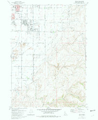
(4)- 1980 Map of Circular Butte
 1980 Circular Butte1980 Print · USGSEastern Idaho at the start of the eighties shows a landscape of federal research and agricultural expansion. Trace the growth of nuclear history at the Idaho National Engineering Laboratory and early settlements like Monteview, Terreton, and Sage Junction.
 - 1981 Map of Ammon
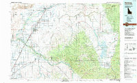
 1981 Ammon1981 Print · USGSAmmon and the outskirts of Idaho Falls are shown in the early eighties as residential growth meets the irrigation canals and gravel pits. Trace local history through the Iona Cemetery, the Union Pacific rail corridor, and the Sandy Downs Rodeo Grounds.3 unique versions available
 - 1986 Map of Palisades, 1987 Print
 1986 Palisades1987 Print · USGSThe Idaho-Wyoming borderlands are captured here in the mid-1980s, where the high ridges of the Caribou Range meet the vital Snake River corridor. Researchers can trace the water-management history of Palisades Reservoir or locate the Monte Cristo Mine and Evergreen Mine near the Caribou Basin.2 unique versions available
 - 1988 Map of Rexburg, 1989 Print
 1988 Rexburg1989 Print · USGSThe Upper Snake River Valley in the late eighties shows a region shaped by water and agriculture. Genealogists and historians can locate family plots at the Rexburg Cemetery or trace the early paths of the Union Pacific Railroad through towns like Sugar City and Newdale.
End of results
Showing maps 1-4 of 4
Top cities near Idaho Falls
- Ammon historical maps
- Rigby historical maps
- Iona historical maps
- Ucon historical maps
- Menan historical maps
- Roberts historical maps
See more
Top neighborhoods of Idaho Falls
- North Idaho Falls historical maps
- South Idaho Falls historical maps
- Downtown historical maps
- Snake River Landing historical maps
- West Idaho Falls historical maps
Frequently asked questions
- What are the different types of historical maps available for Idaho Falls?
- What is the oldest map of Idaho Falls?
- Where can I purchase historical maps of Idaho Falls for my home or office?
- Where can I download high-res historical maps of Idaho Falls?
- Are there historical topographic maps available for Idaho Falls?
- Is there historical aerial imagery available for Idaho Falls?
- Where are historical maps of Idaho Falls sourced from?