1940s Maps of Jefferson County, Idaho
Explore 6 historic maps of Jefferson County from the 1940s. These maps offer a rare glimpse into what life looked like during the 1940s — showing old roads, neighborhoods, homes, and landmarks that have changed or disappeared over time.
Whether you're researching your family's past, planning a metal detecting trip, or studying how Jefferson County's landscape evolved across the 1940s, these high-resolution maps are a powerful tool for exploring the history of this region.
- Focus on a specific era: All maps on this page are from the 1940s, giving you a focused view of this time period.
- See what’s changed: Compare century-old streets, trails, and buildings to today's modern landscape using overlays and satellite layers.
- Research with precision: Use these maps for genealogy, historical research, land use analysis, or educational projects.
- View, download, or print: Maps are fully viewable online in high resolution, and can be downloaded or printed for your own records.
Start exploring Jefferson County's history through authentic maps from the 1940s. This is your window into the past.
Jefferson County, ID maps
(6)- 1948 Map of Rigby, 1959 Print
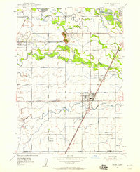 1948 Rigby1959 Print · USGSThe Upper Snake River Valley comes to life in this post-war survey, showing the agricultural engine of Jefferson County. Genealogists and local historians can trace the irrigation network through dozens of named features like the Rigby Canal or locate landmarks such as Garfield Sch and the Little Buttes.
 - 1948 Map of Lewisville, 1959 Print
 1948 Lewisville1959 Print · USGSSoutheastern Idaho's agricultural heartland is captured here in the late 1940s, showing a complex web of canals and riverfront settlements. Researchers can trace family roots through the Lewisville Cemetery, Midway High Sch, and the rail stops at Roberts and Bassett.3 unique versions available
 - 1949 Map of Rigby
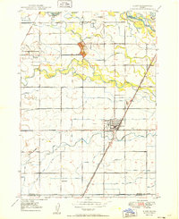 1949 Rigby1949 Print · USGSJefferson County in the late 1940s is defined by a massive irrigation network surrounding Rigby and Menan. Genealogists and historians can trace the paths of the Union Pacific, locate the Garfield Sch, and study the complex system of the Burgess Canal.3 unique versions available
 - 1949 Map of Lewisville
 1949 Lewisville1949 Print · USGSEastern Idaho's irrigation and rail networks are expertly detailed here in the late 1940s as the Snake River valley prospered. Genealogists and local historians can trace the foundations of Lewisville, locate the Central Cem, and find rural landmarks like Grant School.
 - 1949 Map of Roberts, 1959 Print
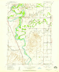
 1949 Roberts1959 Print · USGSThe Upper Snake River Plain comes alive in the late 1940s, showing a landscape defined by industrial irrigation and rail-side settlements. Genealogists and historians can trace the foundations of local communities at Lewisville Cem, Grant Sch, and Oakland Valley.
 - 1949 Map of Roberts, 1966 Print
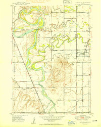
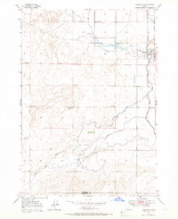 1949 Roberts1966 Print · USGSIn the Idaho high desert at the close of the 1940s, the village of Roberts stands at the intersection of rail and water. Local researchers can trace the detailed irrigation network of Mc Carthy Ditch and the Union Pacific line as it skirts Market Lake.4 unique versions available
End of results
Showing maps 1-6 of 6
Top cities of Jefferson County
- Rigby historical maps
- Menan historical maps
- Roberts historical maps
- Ririe historical maps
- Lewisville historical maps
- Mud Lake historical maps
Frequently asked questions
- What are the different types of historical maps available for Jefferson County?
- What is the oldest map of Jefferson County?
- Where can I purchase historical maps of Jefferson County for my home or office?
- Where can I download high-res historical maps of Jefferson County?
- Are there historical topographic maps available for Jefferson County?
- Is there historical aerial imagery available for Jefferson County?
- Where are historical maps of Jefferson County sourced from?