1980s Maps of Latah County, Idaho
Explore 9 historic maps of Latah County from the 1980s. These maps offer a rare glimpse into what life looked like during the 1980s — showing old roads, neighborhoods, homes, and landmarks that have changed or disappeared over time.
Whether you're researching your family's past, planning a metal detecting trip, or studying how Latah County's landscape evolved across the 1980s, these high-resolution maps are a powerful tool for exploring the history of this region.
- Focus on a specific era: All maps on this page are from the 1980s, giving you a focused view of this time period.
- See what’s changed: Compare century-old streets, trails, and buildings to today's modern landscape using overlays and satellite layers.
- Research with precision: Use these maps for genealogy, historical research, land use analysis, or educational projects.
- View, download, or print: Maps are fully viewable online in high resolution, and can be downloaded or printed for your own records.
Start exploring Latah County's history through authentic maps from the 1980s. This is your window into the past.
Latah County, ID maps
(9)- 1981 Map of St Maries
 1981 St Maries1981 Print · USGSThe timber and rail hub of St. Maries is captured here in the early 1980s as the river-and-rail economy defined the Panhandle. Researchers can trace historic transport corridors including the Union Pacific tracks and remote landings along the St Joe River and Chatcolet Lake.2 unique versions available
 - 1981 Map of Potlatch, 1982 Print
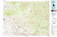 1981 Potlatch1982 Print · USGSLatah County and the northern Nez Perce Reservation are shown here in the early 1980s, documenting the rail-and-river network of the Idaho panhandle. Researchers can trace historic transport lines like the Burlington Northern and find remote landmarks such as the Gold Hill Mine and Potato Hill.2 unique versions available
 - 1982 Map of Pullman
 1982 Pullman1982 Print · USGSThe Palouse region and Snake River valley are shown in the early eighties as the river navigation system matured. Trace the rail lines of the Union Pacific, locate rural centers like Johnson and Colton, and see the impact of the Lower Granite Dam.
 - 1984 Map of Rosalia
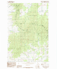
 1984 Rosalia1984 Print · USGSThe Palouse region of Eastern Washington and the Idaho borderlands are shown here in the mid-1980s, a landscape of rolling wheat fields and vital rail corridors. Genealogists and historians can trace the early layout of Cheney, the rail junctions at Rosalia, and the distinct topography of Steptoe Butte.
 - 1985 Map of Mission Mountain
 1985 Mission Mountain1985 Print · USGSThe northern Idaho timberlands and high ridges come into focus in the mid-1980s, documenting the overlapping boundaries of state and federal lands. Genealogists and historians can trace routes through Mary Minerva Mc Croskey Memorial State Park and along Mountain Jack Lane or Silver Creek.
 - 1985 Map of Sanders
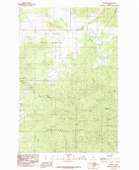 1985 Sanders1985 Print · USGSNorthern Idaho in the mid-eighties shows a landscape of timber and tribal lands where the reservation and national forest meet. Researchers can find the small settlement of Sanders, the local Cem, and landmarks like Prospect Peak and Marsh Hill.
 - 1985 Map of Emida
 1985 Emida1985 Print · USGSThe mountain settlement of Emida is shown here in the mid-1980s, positioned where the St Joe National Forest meets the Hoodoo Mountains. Researchers can trace old timber and mining routes through California Gulch or locate high-altitude landmarks like Bald Mountain and the Lookout Tower.
 - 1985 Map of Tensed
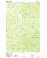
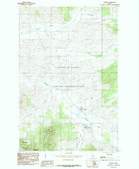 1985 Tensed1985 Print · USGSTensed and De Smet sit within the Coeur D'Alene Indian Reservation during the mid-eighties, where the agricultural Palouse meets timbered ridges. Researchers can trace land use through elevators, a Clay Pit, and the Mary Minerva Mc Croskey Memorial State Park.
 - 1985 Map of West Dennis
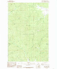 1985 West Dennis1985 Print · USGSThe timberlands of northern Idaho appear here in the mid-1980s, centered on the high ridges of the St Joe National Forest. Researchers can trace the drainages of Santa Creek and Hangman Creek or locate landmarks like West Dennis and Three Tree Butte.
End of results
Showing maps 1-9 of 9
Top cities of Latah County
- Moscow historical maps
- Genesee historical maps
- Troy historical maps
- Potlatch historical maps
- Juliaetta historical maps
- Deary historical maps
See more
Frequently asked questions
- What are the different types of historical maps available for Latah County?
- What is the oldest map of Latah County?
- Where can I purchase historical maps of Latah County for my home or office?
- Where can I download high-res historical maps of Latah County?
- Are there historical topographic maps available for Latah County?
- Is there historical aerial imagery available for Latah County?
- Where are historical maps of Latah County sourced from?