1960s Maps of Latah County, Idaho
Explore 17 historic maps of Latah County from the 1960s. These maps offer a rare glimpse into what life looked like during the 1960s — showing old roads, neighborhoods, homes, and landmarks that have changed or disappeared over time.
Whether you're researching your family's past, planning a metal detecting trip, or studying how Latah County's landscape evolved across the 1960s, these high-resolution maps are a powerful tool for exploring the history of this region.
- Focus on a specific era: All maps on this page are from the 1960s, giving you a focused view of this time period.
- See what’s changed: Compare century-old streets, trails, and buildings to today's modern landscape using overlays and satellite layers.
- Research with precision: Use these maps for genealogy, historical research, land use analysis, or educational projects.
- View, download, or print: Maps are fully viewable online in high resolution, and can be downloaded or printed for your own records.
Start exploring Latah County's history through authentic maps from the 1960s. This is your window into the past.
Latah County, ID maps
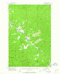
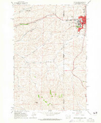
(17)- 1960 Map of Troy, 1961 Print
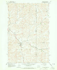
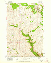 1960 Troy1961 Print · USGSLatah County at the dawn of the 1960s shows a landscape of upland ridges and winding rail lines. Genealogists and local historians can trace the Northern Pacific tracks through Cornwall and Joel, or locate the Aspendale Community Hall.2 unique versions available
 - 1960 Map of Robinson Lake, 1961 Print
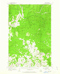
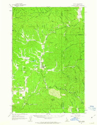
 1960 Robinson Lake1961 Print · USGSLatah County at the start of the 1960s is defined by the high peaks of the Palouse Range and its complex network of mountain streams. Trace the local topography from Paradise Point down to the White Cross Mine and the waters of Robinson Lake.3 unique versions available
 - 1960 Map of Moscow Mtn, 1961 Print
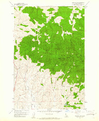
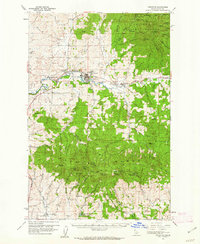
 1960 Moscow Mtn1961 Print · USGSThe northern Idaho highlands are shown here in the early sixties as the timbered Palouse Range meets the agricultural flats. Genealogists and historians can locate the Beulah Cem and trace early mountain infrastructure like the Moscow Mtn Lookout.5 unique versions available
 - 1960 Map of Moscow East, 1961 Print
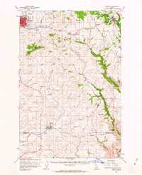
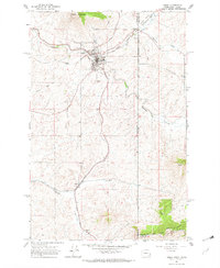
 1960 Moscow East1961 Print · USGSThe growing university town of Moscow and its surrounding Idaho wheat country are captured here at the start of the 1960s. Researchers can trace the early urban footprints of Russell School and St. Mary's School or follow the Northern Pacific line past Joel.3 unique versions available
 - 1960 Map of Potlatch, 1962 Print
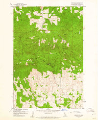
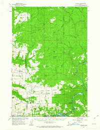
 1960 Potlatch1962 Print · USGSLatah County timber and rail culture are on full display in the early 1960s as the Washington Idaho and Montana Railway threads through the river valley. Researchers can trace historic industrial sites like the Wheelbarrow Mine and locate rural hubs like Potlatch and Onaway.2 unique versions available
 - 1961 Map of Deary, 1963 Print
 1961 Deary1963 Print · USGSLatah County timberlands and collegiate-named settlements come to life in this early 1960s survey. Genealogists and historians can trace rail-era towns like Deary and Avon, or locate family sites at Zion Cem and the Gold Bug Mine.2 unique versions available
 - 1961 Map of Kendrick, 1963 Print
 1961 Kendrick1963 Print · USGSThe Potlatch and Clearwater river valleys were bustling rail and timber corridors in the early sixties. Genealogists can trace family roots through numerous upland burial sites like Little Bear Ridge Cem and American Ridge Cem, or locate the schools and homesteads near Kendrick and Juliaetta.2 unique versions available
 - 1961 Map of Ahsahka, 1963 Print
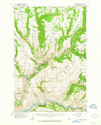
 1961 Ahsahka1963 Print · USGSThe Clearwater River country of the early sixties is shown here at the confluence of its north and main forks. Genealogists and local historians can locate rural landmarks such as the Teakean-Cavendish School, Sunnyside Cemetery, and the United Brethren Camp.2 unique versions available
 - 1961 Map of Fernwood, 1963 Print
 1961 Fernwood1963 Print · USGSThe St Maries River valley and the surrounding timberlands are captured here in the early 1960s. Researchers can trace the route of the Chicago Milwaukee St Paul and Pacific railroad through Fernwood and find local landmarks like the Cem at Santa.2 unique versions available
 - 1961 Map of Bovill, 1963 Print
 1961 Bovill1963 Print · USGSBovill and Helmer are captured during a period of active rail and mining operations in the Idaho panhandle. Researchers can trace the Milwaukee Road through the timberlands, locating the Mizpah Mine, local Claypits, and the Cem near Bovill.2 unique versions available
 - 1961 Map of Moscow, 1963 Print
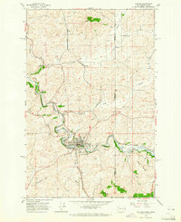
 1961 Moscow1963 Print · USGSThe Latah County wheat country and rail corridors are frozen in time here during the early sixties. Genealogists and local historians can trace the Northern Pacific line through Genesee, locate the Aspendale Community Hall, and find remote burials at Fix Ridge Cem.2 unique versions available
 - 1964 Map of Viola, 1965 Print
 1964 Viola1965 Print · USGSThe Palouse hills along the Washington and Idaho border come alive in the mid-1960s, showing a landscape defined by timbered buttes and vital rail lines. Genealogists and rail historians can trace the paths of the Northern Pacific through rural stops like Fallon, Viola, and Whelan.2 unique versions available
 - 1964 Map of Moscow West, 1965 Print
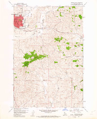
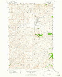
 1964 Moscow West1965 Print · USGSThe Idaho-Washington border comes alive in the mid-1960s, centered on the university town of Moscow and its rail connections. Researchers can trace the junction of the Union Pacific and Great Northern railroads or locate the University of Idaho campus and the old Drive-in Theater.3 unique versions available
 - 1964 Map of Tekoa, 1965 Print
 1964 Tekoa1965 Print · USGSWhitman County and the Idaho borderlands are captured here in the mid-1960s, centered on the vital rail junction at Tekoa. Researchers can trace the dual paths of the Union Pacific and Milwaukee Road through Seltice and past the Goldenrod Cem.3 unique versions available
 - 1964 Map of Palouse, 1965 Print
 1964 Palouse1965 Print · USGSThe Washington-Idaho borderlands in the mid-sixties are captured here as the grain and rail economy centered on the river thrived. Researchers can trace the lines of the Great Northern railroad, locate the Greenwood Cem, and find old sites like Ladow and Lairds.2 unique versions available
 - 1964 Map of Farmington, 1965 Print
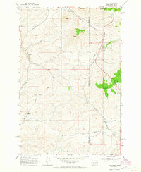
 1964 Farmington1965 Print · USGSCrossing the Washington-Idaho border in the 1960s, this survey reveals the agricultural and rail-dependent landscape around Farmington. Local historians can trace the paths of the Union Pacific and Great Northern railroads or locate family plots at Silver Creek Cemetery.2 unique versions available
 - 1964 Map of Uniontown, 1965 Print
 1964 Uniontown1965 Print · USGSThe Washington-Idaho border comes alive in the mid-1960s, showing the agricultural heart of the Palouse. Genealogists can trace family roots at Uniontown and Colton, or locate landmarks like the St Boniface Sch and Thorn Creek Ranch.
End of results
Showing maps 1-17 of 17
Top cities of Latah County
- Moscow historical maps
- Genesee historical maps
- Troy historical maps
- Potlatch historical maps
- Juliaetta historical maps
- Deary historical maps
See more
Frequently asked questions
- What are the different types of historical maps available for Latah County?
- What is the oldest map of Latah County?
- Where can I purchase historical maps of Latah County for my home or office?
- Where can I download high-res historical maps of Latah County?
- Are there historical topographic maps available for Latah County?
- Is there historical aerial imagery available for Latah County?
- Where are historical maps of Latah County sourced from?