2000-2009 Maps of Oneida County, Idaho
Explore 4 historic maps of Oneida County from 2000-2009. These maps offer a rare glimpse into what life looked like during the 2000s — showing old roads, neighborhoods, homes, and landmarks that have changed or disappeared over time.
Whether you're researching your family's past, planning a metal detecting trip, or studying how Oneida County's landscape evolved across the 2000s, these high-resolution maps are a powerful tool for exploring the history of this region.
- Focus on a specific era: All maps on this page are from the 2000s, giving you a focused view of this time period.
- See what’s changed: Compare century-old streets, trails, and buildings to today's modern landscape using overlays and satellite layers.
- Research with precision: Use these maps for genealogy, historical research, land use analysis, or educational projects.
- View, download, or print: Maps are fully viewable online in high resolution, and can be downloaded or printed for your own records.
Start exploring Oneida County's history through authentic maps from the 2000s. This is your window into the past.
Oneida County, ID maps
(4)- 2001 Map of Sweetzer Canyon, 2006 Print
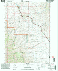 2001 Sweetzer Canyon2006 Print · USGSThe high ridges of Cassia County meet at the turn of the century, showing a remote landscape where mountain ranges and national forest lands converge. Researchers can trace seasonal water sources and high-elevation landmarks like Sweetzer Summit, Indian Spring, and the Black Pine Mountains.
 - 2001 Map of Sublett Troughs, 2006 Print
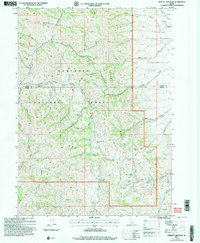 2001 Sublett Troughs2006 Print · USGSOneida County's high-country terrain at the turn of the millennium preserves the path of western emigrants within the Sawtooth National Forest. Researchers can trace the California National Historic Trail and Hudspeth Cut-Off near Eyrie Peak and Rock Sublett Troughs.
 - 2001 Map of Curlew Junction, 2006 Print
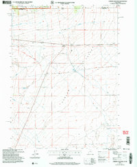 2001 Curlew Junction2006 Print · USGSThe high desert of Box Elder County comes into focus at the turn of the 21st century, revealing a landscape defined by westward migration and modern water management. Trace the historic Salt Lake Cut-Off past landmarks like Pilot Spring and the Curlew Junction crossroads.
 - 2001 Map of Sublett Reservoir, 2006 Print
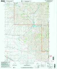 2001 Sublett Reservoir2006 Print · USGSThe high basins of the Sawtooth National Forest were at the center of pioneering history as westward migrants followed the Sublett Cut-Off. Trace the California Historic National Trail as it passes through the Sublett Range and by the Broken Circle Ranch.
End of results
Showing maps 1-4 of 4
Top cities of Oneida County
Frequently asked questions
- What are the different types of historical maps available for Oneida County?
- What is the oldest map of Oneida County?
- Where can I purchase historical maps of Oneida County for my home or office?
- Where can I download high-res historical maps of Oneida County?
- Are there historical topographic maps available for Oneida County?
- Is there historical aerial imagery available for Oneida County?
- Where are historical maps of Oneida County sourced from?