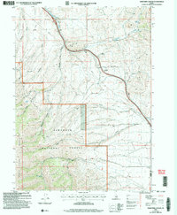
2001 Map of Sweetzer Canyon
USGS Topo · Published 2006About this map
Sawtooth National Forest dominates the southern half of this landscape, where the high ridges of the Black Pine Mountains and the Sublett Range converge. This 2001 revision illustrates a rugged high-desert environment defined by seasonal water sources and steep drainages like Sweetzer Canyon and Jones Canyon. The topography is marked by several perennial water points vital to this arid region, including Indian Spring and Pole Canyon Spring, which are scattered among the canyons and draws.
Find a feature on this map
24 named features on this map. Tap any name to fly to it.
Don’t see what you’re looking for? This feature index may not catch every label — zoom into the map to look around manually.
Map Details
Editions of this 2001 Sweetzer Canyon Map
This is the sole edition of this map. No revisions or reprints were ever made.
Other maps of this area

1954 · Pocatello
USGS Topo · 1:250,000

1958 · Pocatello
USGS Topo · 1:250,000

1958 · Sublett
USGS Topo · 1:62,500

1959 · Strevell
USGS Topo · 1:62,500

1973 · Juniper
USGS Topo · 1:24,000

1973 · Sublett Troughs
USGS Topo · 1:24,000

1973 · Black Pine
USGS Topo · 1:24,000
1984 · Malad City
USGS Topo · 1:100,000
1985 · Sandrock Canyon
USGS Topo · 1:24,000
1985 · Strevell
USGS Topo · 1:24,000