1973 Map of Black Pine
USGS Topo · Published 1977About this map
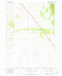
Juniper Valley and Curlew Valley converge along the Idaho-Utah state line in this early 1970s survey. The landscape is defined by its water resources and transportation corridors, featuring a prominent Pipeline and the route of 80n. Settlement history is anchored at Black Pine (Site), with a nearby Cem indicating the deeper roots of this ranching and grazing district.
Find a feature on this map
23 named features on this map. Tap any name to fly to it.
Don’t see what you’re looking for? This feature index may not catch every label — zoom into the map to look around manually.
Map Details
Editions of this 1973 Black Pine Map
This is the sole edition of this map. No revisions or reprints were ever made.
Other maps of this area

1954 · Pocatello
USGS Topo · 1:250,000

1954 · Brigham City
USGS Topo · 1:250,000

1958 · Pocatello
USGS Topo · 1:250,000

1958 · Brigham City
USGS Topo · 1:250,000

1959 · Strevell
USGS Topo · 1:62,500

1959 · Kelton Pass
USGS Topo · 1:62,500

1962 · Brigham City
USGS Topo · 1:250,000
1968 · Monument Peak NW
USGS Topo · 1:24,000
1968 · Monument Peak NE
USGS Topo · 1:24,000
1973 · Juniper
USGS Topo · 1:24,000