2000-2009 Maps of Twin Falls County, Idaho
Explore 5 historic maps of Twin Falls County from 2000-2009. These maps offer a rare glimpse into what life looked like during the 2000s — showing old roads, neighborhoods, homes, and landmarks that have changed or disappeared over time.
Whether you're researching your family's past, planning a metal detecting trip, or studying how Twin Falls County's landscape evolved across the 2000s, these high-resolution maps are a powerful tool for exploring the history of this region.
- Focus on a specific era: All maps on this page are from the 2000s, giving you a focused view of this time period.
- See what’s changed: Compare century-old streets, trails, and buildings to today's modern landscape using overlays and satellite layers.
- Research with precision: Use these maps for genealogy, historical research, land use analysis, or educational projects.
- View, download, or print: Maps are fully viewable online in high resolution, and can be downloaded or printed for your own records.
Start exploring Twin Falls County's history through authentic maps from the 2000s. This is your window into the past.
Twin Falls County, ID maps
(5)- 2001 Map of Hopper Gulch, 2006 Print
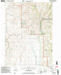 2001 Hopper Gulch2006 Print · USGSShoshone Basin is captured here during the early years of the new millennium as it appeared under the management of the Forest Service. Tracing the water sources across the Sawtooth National Forest reveals sites like Alvins Well, Fourth of July Spring, and the Landing Strip.
 - 2001 Map of Pike Mountain, 2006 Print
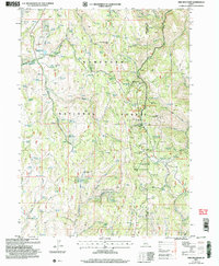 2001 Pike Mountain2006 Print · USGSThe Sawtooth high country of Twin Falls County comes into focus at the turn of the millennium, showing a landscape shaped by seasonal recreation and forestry. Researchers can trace the layout of the Magic Mountain Ski Area, the Historic Shoshone Cabin Site, and summer communities like the Balsam Summer Homes Area.
 - 2001 Map of Timber Butte, 2006 Print
 2001 Timber Butte2006 Print · USGSThe Sawtooth National Forest at the turn of the millennium was a landscape of remote ridges and vital water sources along the Idaho-Nevada state line. Genealogists and historians can trace old homestead sites and water rights through landmarks like Timber Butte, Box Canyon Spring, and the Hot Springs.
 - 2001 Map of Big Creek Ranch, 2006 Print
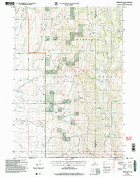
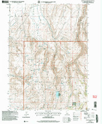
 2001 Big Creek Ranch2006 Print · USGSThe Idaho-Nevada borderlands near Twin Falls come into focus at the turn of the century as a landscape of remote ranching and geothermal features. Genealogists and historians can trace the bounds of Big Creek Ranch and the route of Magic Hot Springs Road through the Shoshone Basin.
 - 2001 Map of McMullen Basin, 2006 Print
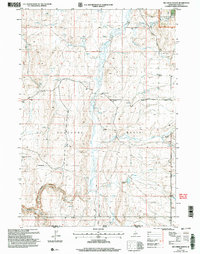
 2001 McMullen Basin2006 Print · USGSThe high basins and forest ridges of southern Idaho are captured here at the turn of the millennium. Researchers can trace the water and livestock infrastructure of the Sawtooth National Forest, from the McMullen Cow Camp to remote catchments like Williams Reservoir and Moonshine Spring.
End of results
Showing maps 1-5 of 5
Top cities of Twin Falls County
- Twin Falls historical maps
- Buhl historical maps
- Kimberly historical maps
- Filer historical maps
- Hansen historical maps
- Castleford historical maps
See more
Frequently asked questions
- What are the different types of historical maps available for Twin Falls County?
- What is the oldest map of Twin Falls County?
- Where can I purchase historical maps of Twin Falls County for my home or office?
- Where can I download high-res historical maps of Twin Falls County?
- Are there historical topographic maps available for Twin Falls County?
- Is there historical aerial imagery available for Twin Falls County?
- Where are historical maps of Twin Falls County sourced from?