1980s Maps of Adams County, Illinois
Explore 21 historic maps of Adams County from the 1980s. These maps offer a rare glimpse into what life looked like during the 1980s — showing old roads, neighborhoods, homes, and landmarks that have changed or disappeared over time.
Whether you're researching your family's past, planning a metal detecting trip, or studying how Adams County's landscape evolved across the 1980s, these high-resolution maps are a powerful tool for exploring the history of this region.
- Focus on a specific era: All maps on this page are from the 1980s, giving you a focused view of this time period.
- See what’s changed: Compare century-old streets, trails, and buildings to today's modern landscape using overlays and satellite layers.
- Research with precision: Use these maps for genealogy, historical research, land use analysis, or educational projects.
- View, download, or print: Maps are fully viewable online in high resolution, and can be downloaded or printed for your own records.
Start exploring Adams County's history through authentic maps from the 1980s. This is your window into the past.
Adams County, IL maps
(21)- 1981 Map of Columbus
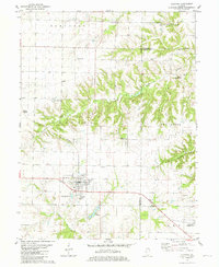
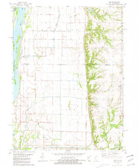
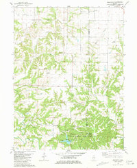
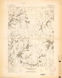 1981 Columbus1981 Print · USGSAdams County in the early eighties was defined by its rolling creek drainages and quiet township crossroads. Genealogists and local historians can trace family sites at Mt Pleasant Cem and Independence Cem, or locate landmarks like the Townhall near Burton.2 unique versions available
 - 1981 Map of Tioga
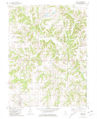
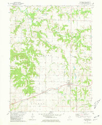
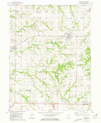
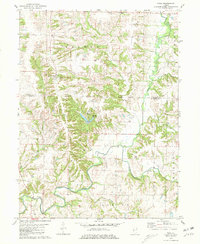 1981 Tioga1981 Print · USGSWestern Illinois farm country at the start of the eighties shows a landscape of deep creek valleys and quiet rural crossroads. Genealogists can trace family names at Bethany Cem and Higgins Cem or locate the site of Camp Saukenauk.
 - 1981 Map of Fishhook
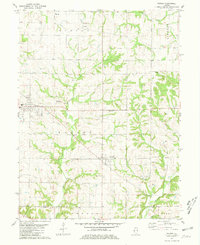
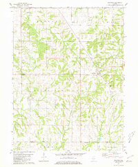
 1981 Fishhook1981 Print · USGSThe rural borderlands of Adams and Pike Counties are captured here in the early 1980s. Researchers can locate family burial plots and old country churches like Mound Prairie Ch, Winner Cem, and the settlement at Chestline.
 - 1981 Map of Loraine
 1981 Loraine1981 Print · USGSThe West-Central Illinois prairie during the early 1980s reveals a structured landscape of crossroads hamlets and family farmsteads. Researchers can trace genealogical roots through local sites like Old Loraine Cem, Centennial Ebenezer Ch, and the settlement at Stillwell.
 - 1981 Map of Clayton
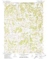
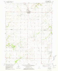
 1981 Clayton1981 Print · USGSWestern Illinois farm country and the village of Clayton are captured here in the early eighties. Researchers can locate numerous family burial grounds including Knight Cem and Howe Cem, or trace the rail-era footprint of Timewell (Mound Station).
 - 1981 Map of Liberty
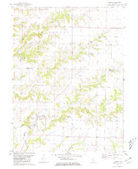
 1981 Liberty1981 Print · USGSAdams County’s rural landscape is captured here in the early eighties, showing the deeply etched creek valleys and scattered homesteads near Liberty. Genealogists can trace family names through dozens of local burial sites like Nations Cem, Coats Cem, and Earel Cem.
 - 1981 Map of Bowen
 1981 Bowen1981 Print · USGSThis rural portion of Hancock and Adams Counties was captured in the early eighties as the agricultural grid defined the landscape. Researchers can locate family sites such as Ebenezer Cem and Forsyth Cem or trace the Burlington Northern rail line through La Prairie.
 - 1981 Map of Augusta
 1981 Augusta1981 Print · USGSAugusta and the surrounding Illinois prairie are shown here in the early eighties, centered on the BURLINGTON NORTHERN railroad and the Augusta town grid. Family historians can trace local roots at Woodland Cemetery, Elm Grove Church, and several smaller burial grounds scattered near Pulaski.
 - 1981 Map of Lima
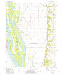
 1981 Lima1981 Print · USGSThe Mississippi River floodplain and upland bluffs of Adams County are captured here in the early 1980s. Local researchers can locate family burial sites at Fletcher Cem and Gallimore Cem or trace river geography near Buzzard Island.
 - 1981 Map of Long Island
 1981 Long Island1981 Print · USGSThe Mississippi River valley near the Illinois-Missouri border is captured here in the early 1980s. Historians and researchers can trace the riverfront at La Grange and explore the natural geography of the National Mark Twain Wildlife Refuge.
 - 1981 Map of Coatsburg
 1981 Coatsburg1981 Print · USGSThe railroad villages of Coatsburg and Paloma anchor this rural landscape during the early 1980s. Local historians can trace many family-named burial sites including Gray Mount Cem and Gooding Cem, alongside the Burlington Northern line.
 - 1981 Map of Payson
 1981 Payson1981 Print · USGSSouthern Adams County in the early eighties reveals a landscape of wooded creek valleys and prairie farmsteads. Researchers can trace numerous local burial sites like Steward Cem and New Town Cem or locate rural landmarks such as the Krutmeier Landing Strip.
 - 1981 Map of Kellerville
 1981 Kellerville1981 Print · USGSThe border of Adams and Brown counties in the early 1980s reveals a rural landscape shaped by the Mc Kee Creek drainage and the development of Siloam Springs State Park. Genealogists can trace numerous family burial sites like Amen Cem and Higley Cem alongside the village of Kellerville.
 - 1981 Map of Mendon
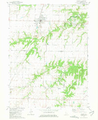
 1981 Mendon1981 Print · USGSNorthern Adams County is captured here in the early eighties as a landscape of established farmsteads and rural townships. Trace family roots at Wesley Chapel Cem, Booth Cem, or the County Fairground near Mendon.
 - 1981 Map of Richfield
 1981 Richfield1981 Print · USGSRichfield and Kingston were established rural centers in the early eighties as the Adams and Pike county line remained a landscape of family farms. Genealogists can trace local heritage through numerous sites like Klarner Cem, Steward Cem, and Potter Cem.
 - 1981 Map of Camp Point
 1981 Camp Point1981 Print · USGSEastern Adams County in the early eighties shows a landscape shaped by agricultural traditions and the Burlington Northern rail line. Genealogists and local historians can trace family roots through Evergreen Cem, Yorkneck Cem, and the rural community of Golden.
 - 1985 Map of Macomb
 1985 Macomb1985 Print · USGSWest Central Illinois in the mid-eighties shows a robust network of river towns and rail corridors spanning from the Illinois River to the Lamoine. Genealogists and historians can trace the foundations of Macomb, find rural landmarks like Pennington Point, or locate early conservation sites like Argyle Lake State Park.
 - 1985 Map of Meredosia, 1988 Print
 1985 Meredosia1988 Print · USGSWest Central Illinois in the mid-eighties was a landscape of deep-rooted river towns and historic educational institutions. Genealogists and historians can trace family ties through Diamond Grove Cem, locate MacMurray College in Jacksonville, or study the river engineering at La Grange Lock and Dam.
 - 1986 Map of Quincy
 1986 Quincy1986 Print · USGSThe tri-state border region along the Mississippi River comes into focus during the mid-1980s. Researchers can trace the legacy of river towns and rail hubs like Quincy and Monroe City or locate landmarks such as Mount Olive Cem.2 unique versions available
 - 1986 Map of Keokuk
 1986 Keokuk1986 Print · USGSThe tri-state junction of Iowa, Illinois, and Missouri comes alive in the mid-eighties as a hub of river commerce and rail transit. Researchers can trace family roots through Moss Ridge Cemetery or study industrial landmarks like the Keokuk Dam and Lock and Dam No 19.2 unique versions available
 - 1989 Map of Macomb
 1989 Macomb1989 Print · USGSWest Central Illinois in the late eighties shows a landscape of river-bottom conservation and rail-town commerce. Researchers can trace the extensive wetlands of the Illinois River or locate historic transport hubs in Macomb, Colchester, and Beardstown.
End of results
Showing maps 1-21 of 21
Top cities of Adams County
- Quincy historical maps
- Camp Point historical maps
- Payson historical maps
- Mendon historical maps
- Clayton historical maps
- Burton historical maps
See more
Frequently asked questions
- What are the different types of historical maps available for Adams County?
- What is the oldest map of Adams County?
- Where can I purchase historical maps of Adams County for my home or office?
- Where can I download high-res historical maps of Adams County?
- Are there historical topographic maps available for Adams County?
- Is there historical aerial imagery available for Adams County?
- Where are historical maps of Adams County sourced from?