Old Maps of Adams County, Illinois for Academic Research
Study the evolution of Adams County with 167 high-resolution historic maps. Whether you're teaching, researching, or modeling changes in land use, these maps provide essential visual documentation of urban, environmental, and geographic change.
- Analyze long-term change: Track patterns in development, transportation, and natural features.
- Ideal for environmental or urban studies: Support academic projects with primary historical map data.
- Use in the classroom or lab: Educators and researchers rely on these maps to bring historical context to life.
These maps are a powerful tool for teaching, research, and visualizing how Adams County has changed over the decades.
Adams County, IL maps
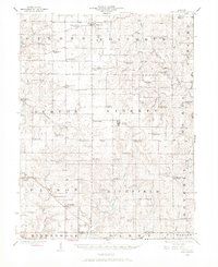
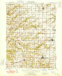
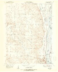
(167)- 1903 Map of Kahoka
 1903 Kahoka1903 Print · USGSNortheast Missouri at the turn of the century shows a landscape defined by the convergence of major rivers and competing rail lines. Genealogists can trace family roots in early centers like Kahoka and Monticello, or locate riverfront crossings at St. Francisville and Canton.3 unique versions available
 - 1925 Map of Quincy
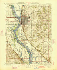
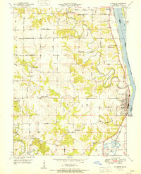
 1925 Quincy1925 Print · USGSQuincy and its Mississippi River hinterlands are captured in the mid-1920s, showing a landscape defined by river navigation and rail transport. Genealogists can locate dozens of country schools and churches, from St Ludgerus School to Zion Church and the Soldiers Home.2 unique versions available
 - 1925 Map of Liberty, 1972 Print
 1925 Liberty1972 Print · USGSWestern Illinois in the 1920s was a landscape of tightly knit farming communities and country crossroads. Genealogists and researchers can trace family roots through dozens of local landmarks like St Joseph School, Mt Pleasant Church, and the village of Plainville.
 - 1926 Map of Mt Sterling, 1970 Print
 1926 Mt Sterling1970 Print · USGSWestern Illinois at the mid-twenties reveals a landscape of ridge-top farms and creek-bottom crossings across Brown and Pike counties. You can trace the locations of dozens of vanished rural schoolhouses like Pea Green Sch and old river fords including Wilson Ford.
 - 1927 Map of Liberty
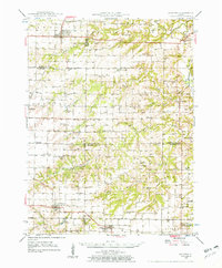
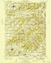
 1927 Liberty1927 Print · USGSAdams County’s rural townships are captured here during the mid-1920s, showing a landscape of small agricultural settlements and tight-knit communities. Family historians can locate dozens of country schools and churches, including Seigel School, Tandy School, and Pleasant Grove Church.2 unique versions available
 - 1929 Map of Mt Sterling
 1929 Mt Sterling1929 Print · USGSIn the late 1920s, the borderlands of Brown and Pike counties were defined by a dense network of country schools and creek crossings. Genealogists can trace family farms and local hubs like Pea Green Sch, Fishhook, and Mountain View Ch, or locate the historic Shinnebarger Bridge on McKee Creek.2 unique versions available
 - 1944 Map of Quincy, 1954 Print
 1944 Quincy1954 Print · USGSQuincy and the Mississippi River valley are captured in the 1940s, showing a landscape defined by rail lines and rural parish schools. Researchers can trace the riverfront at Marion City, the grounds of the Soldiers Home, and historic sites like Zion Church.5 unique versions available
 - 1945 Map of Quincy
 1945 Quincy1945 Print · USGSQuincy and its Mississippi River crossings are captured here in the mid-1940s during a period of transition for its riverfront and rail lines. Genealogists can trace family roots at local landmarks like the Soldiers Home, Melrose Chapel, and numerous rural schoolhouses such as Hickory Grove School.2 unique versions available
 - 1946 Map of Augusta, 1957 Print
 1946 Augusta1957 Print · USGSWestern Illinois farm country at the end of the 1940s is detailed here as the rail-and-river economy transitions. Genealogists can trace family names at Sherwood Cem and Woodland Cem, or locate rural landmarks like Mt Horeb Ch and Timewell PO.2 unique versions available
 - 1946 Map of Mendon, 1958 Print
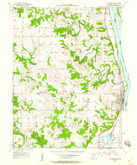
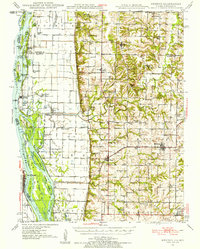 1946 Mendon1958 Print · USGSThe fertile bottomlands of Adams County are seen here in the mid-1940s, as massive drainage projects reshaped the Mississippi River's eastern bank. Genealogists can locate family names and sites through numerous rural landmarks like Wesley Chapel Cem, Gentry Sch, and the Canton Ferry.
 - 1948 Map of Quincy
 1948 Quincy1948 Print · USGSThe Mississippi and Illinois River valleys are captured at a post-war crossroads as rail and river travel met the expanding highway system. Genealogists can trace family settlements from Quincy to Hannibal and smaller towns like Vandalia and Jerseyville.2 unique versions available
 - 1948 Map of Mendon
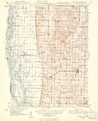 1948 Mendon1948 Print · USGSUpper Adams County in the late 1940s reveals a landscape defined by Mississippi River engineering and tight-knit rural communities. Researchers can trace ancestral locations at New Providence Cem, several dozen one-room schoolhouses like Golden Sch, and the winding Bear Creek drainage.2 unique versions available
 - 1948 Map of Camp Point
 1948 Camp Point1948 Print · USGSWestern Illinois farm country thrives in the late 1940s, marked by a dense grid of township roads and early rail connections. Genealogists can locate dozens of country schools and burial grounds, from Lone Star Sch to the Friedhof Cem and Bowen Cem.2 unique versions available
 - 1949 Map of Augusta
 1949 Augusta1949 Print · USGSWestern Illinois at the end of the 1940s reveals a landscape of tight-knit rural communities and school districts. Genealogists can trace family footprints across dozens of local landmarks like Sulphur Springs Sch, Woodland Cem, and Mound Station Timewell PO.
 - 1950 Map of La Grange, 1959 Print
 1950 La Grange1959 Print · USGSLewis County river towns and rural townships thrive along the Mississippi in the early fifties. Genealogists can trace family roots through numerous country schools like Pink Prairie Sch and the Marks Memorial Cem near La Grange.2 unique versions available
 - 1950 Map of Canton, 1967 Print
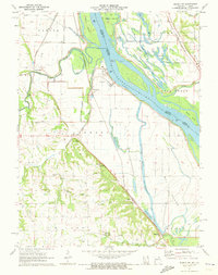
 1950 Canton1967 Print · USGSMissouri river life at mid-century centered on the busy transit hub of Canton and its surrounding rural school districts. Genealogists and historians can trace local landmarks like Culver-Stockton College, the Canton Ferry, and numerous country schools from Hardin Sch to Melrose Sch.3 unique versions available
 - 1951 Map of Canton
 1951 Canton1951 Print · USGSThe Missouri-Illinois river border comes alive in the early fifties, showing the riverside economy of Canton and its connection to Meyer. Genealogists and historians can trace numerous country schools like Hazel Grove Sch and churches such as Shiloh Ch.2 unique versions available
 - 1951 Map of La Grange
 1951 La Grange1951 Print · USGSLewis County's riverfront and rolling uplands are captured here in the early 1950s as rail and river commerce centered on Canton and La Grange. Genealogists and researchers can trace numerous rural landmarks, from Wyaconda Ch to a high density of country schools like Sunnyside Sch and Porter Sch.
 - 1956 Map of Quincy, 1967 Print
 1956 Quincy1967 Print · USGSThe river and rail corridors of the Illinois-Missouri border are documented here during the mid-1950s. Researchers can trace historic river landings and regional transit hubs from Quincy and Hannibal to smaller settlements like Meredosia and Roodhouse.3 unique versions available
 - 1958 Map of Burlington, 1968 Print
 1958 Burlington1968 Print · USGSThe tri-state river country of Iowa, Illinois, and Missouri is captured here in the mid-fifties, dominated by the Mississippi River and major rail lines. Genealogists and historians can trace the development of river towns like Keokuk or locate the sprawling Iowa Army Ammunition Plant.4 unique versions available
 - 1961 Map of Burlington
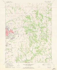
 1961 Burlington1961 Print · USGSThe tri-state borderlands along the Mississippi River are captured here during the late fifties and early sixties, showing the vital river-and-rail economy of Iowa, Illinois, and Missouri. Genealogists and historians can trace the development of major hubs like Galesburg and Macomb alongside landmark sites such as the Iowa Ordnance Plant and the historic river town of Nauvoo.
 - 1963 Map of Burlington
 1963 Burlington1963 Print · USGSThe tri-state river country of the Mississippi and Illinois valleys comes alive in this mid-century survey. Genealogists and historians can trace the industrial and academic growth of the region, from the Iowa Ordnance Plant to campuses like Knox College and Western Illinois University.
 - 1971 Map of Quincy SW, 1973 Print
 1971 Quincy SW1973 Print · USGSMarion County's riverfront landscape is captured here in the early seventies, showing a complex network of levees and sloughs along the Mississippi. Genealogists and local historians can locate numerous family burial grounds including Pennewell Cem, Kaiser Cem, and Thrasher Chapel Cem.
 - 1971 Map of Quincy East, 1973 Print
 1971 Quincy East1973 Print · USGSEastern Quincy and the surrounding Adams County townships are captured here in the early seventies as the city grid pushed toward the rural prairie. Genealogists can locate several family burial grounds including Powell Cem and Eeds Cem, alongside landmarks like Melrose Chapel and Hickory Grove.2 unique versions available
 - 1971 Map of Quincy West, 1973 Print
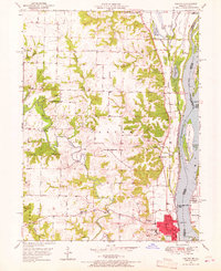
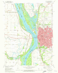 1971 Quincy West1973 Print · USGSThe riverfront city of Quincy is shown in the early seventies, at the height of its mid-century industrial and civic development. Researchers can trace local institutions and family names at Woodland Cem, Quincy College, and the Illinois Soldiers and Sailors Home.
Showing maps 1-25 of 167
Top cities of Adams County
- Quincy historical maps
- Camp Point historical maps
- Payson historical maps
- Mendon historical maps
- Clayton historical maps
- Burton historical maps
See more
Frequently asked questions
- What are the different types of historical maps available for Adams County?
- What is the oldest map of Adams County?
- Where can I purchase historical maps of Adams County for my home or office?
- Where can I download high-res historical maps of Adams County?
- Are there historical topographic maps available for Adams County?
- Is there historical aerial imagery available for Adams County?
- Where are historical maps of Adams County sourced from?