1950s Maps of Adams County, Illinois
Explore 6 historic maps of Adams County from the 1950s. These maps offer a rare glimpse into what life looked like during the 1950s — showing old roads, neighborhoods, homes, and landmarks that have changed or disappeared over time.
Whether you're researching your family's past, planning a metal detecting trip, or studying how Adams County's landscape evolved across the 1950s, these high-resolution maps are a powerful tool for exploring the history of this region.
- Focus on a specific era: All maps on this page are from the 1950s, giving you a focused view of this time period.
- See what’s changed: Compare century-old streets, trails, and buildings to today's modern landscape using overlays and satellite layers.
- Research with precision: Use these maps for genealogy, historical research, land use analysis, or educational projects.
- View, download, or print: Maps are fully viewable online in high resolution, and can be downloaded or printed for your own records.
Start exploring Adams County's history through authentic maps from the 1950s. This is your window into the past.
Adams County, IL maps
(6)- 1950 Map of La Grange, 1959 Print
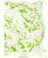 1950 La Grange1959 Print · USGSLewis County river towns and rural townships thrive along the Mississippi in the early fifties. Genealogists can trace family roots through numerous country schools like Pink Prairie Sch and the Marks Memorial Cem near La Grange.2 unique versions available
 - 1950 Map of Canton, 1967 Print
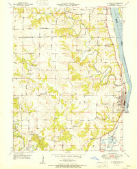
 1950 Canton1967 Print · USGSMissouri river life at mid-century centered on the busy transit hub of Canton and its surrounding rural school districts. Genealogists and historians can trace local landmarks like Culver-Stockton College, the Canton Ferry, and numerous country schools from Hardin Sch to Melrose Sch.3 unique versions available
 - 1951 Map of Canton
 1951 Canton1951 Print · USGSThe Missouri-Illinois river border comes alive in the early fifties, showing the riverside economy of Canton and its connection to Meyer. Genealogists and historians can trace numerous country schools like Hazel Grove Sch and churches such as Shiloh Ch.2 unique versions available
 - 1951 Map of La Grange
 1951 La Grange1951 Print · USGSLewis County's riverfront and rolling uplands are captured here in the early 1950s as rail and river commerce centered on Canton and La Grange. Genealogists and researchers can trace numerous rural landmarks, from Wyaconda Ch to a high density of country schools like Sunnyside Sch and Porter Sch.
 - 1956 Map of Quincy, 1967 Print
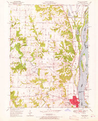
 1956 Quincy1967 Print · USGSThe river and rail corridors of the Illinois-Missouri border are documented here during the mid-1950s. Researchers can trace historic river landings and regional transit hubs from Quincy and Hannibal to smaller settlements like Meredosia and Roodhouse.3 unique versions available
 - 1958 Map of Burlington, 1968 Print
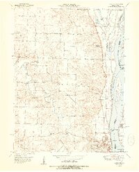
 1958 Burlington1968 Print · USGSThe tri-state river country of Iowa, Illinois, and Missouri is captured here in the mid-fifties, dominated by the Mississippi River and major rail lines. Genealogists and historians can trace the development of river towns like Keokuk or locate the sprawling Iowa Army Ammunition Plant.4 unique versions available
End of results
Showing maps 1-6 of 6
Top cities of Adams County
- Quincy historical maps
- Camp Point historical maps
- Payson historical maps
- Mendon historical maps
- Clayton historical maps
- Burton historical maps
See more
Frequently asked questions
- What are the different types of historical maps available for Adams County?
- What is the oldest map of Adams County?
- Where can I purchase historical maps of Adams County for my home or office?
- Where can I download high-res historical maps of Adams County?
- Are there historical topographic maps available for Adams County?
- Is there historical aerial imagery available for Adams County?
- Where are historical maps of Adams County sourced from?