1930s Maps of Bond County, Illinois
Explore 3 historic maps of Bond County from the 1930s. These maps offer a rare glimpse into what life looked like during the 1930s — showing old roads, neighborhoods, homes, and landmarks that have changed or disappeared over time.
Whether you're researching your family's past, planning a metal detecting trip, or studying how Bond County's landscape evolved across the 1930s, these high-resolution maps are a powerful tool for exploring the history of this region.
- Focus on a specific era: All maps on this page are from the 1930s, giving you a focused view of this time period.
- See what’s changed: Compare century-old streets, trails, and buildings to today's modern landscape using overlays and satellite layers.
- Research with precision: Use these maps for genealogy, historical research, land use analysis, or educational projects.
- View, download, or print: Maps are fully viewable online in high resolution, and can be downloaded or printed for your own records.
Start exploring Bond County's history through authentic maps from the 1930s. This is your window into the past.
Bond County, IL maps
(3)- 1932 Map of Greenville
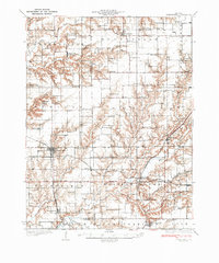 1932 Greenville1932 Print · USGSThis Illinois landscape in the early thirties reveals a bustling agricultural and rail network centered on Greenfield. Genealogists can trace family roots through numerous country burial grounds like Stultz Cem and historic schools such as Oakland Sch.
 - 1937 Map of New Douglas
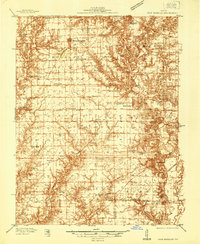 1937 New Douglas1937 Print · USGSMadison and Bond counties are seen here in the late 1930s, showing a high density of rural schools and family cemeteries. Researchers can trace the grounds of Mt Calvary Sch, locate the St Vincent Cem, or follow the Shoal Creek bottomlands.2 unique versions available
 - 1939 Map of Greenville, 1957 Print
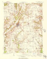 1939 Greenville1957 Print · USGSBond County and the surrounding prairies are captured here in the late thirties, showing a rural economy built on the Pennsylvania railroad and local post offices. Trace the sites of vanished schoolhouses like Pleasant View Sch and old burial grounds such as Dunkard Cem or Mt Moriah Cem.2 unique versions available
End of results
Showing maps 1-3 of 3
Top cities of Bond County
- Greenville historical maps
- Pleasant Mound historical maps
- Pocahontas historical maps
- Tamalco historical maps
- Mulberry Grove historical maps
- Pierron historical maps
See more
Frequently asked questions
- What are the different types of historical maps available for Bond County?
- What is the oldest map of Bond County?
- Where can I purchase historical maps of Bond County for my home or office?
- Where can I download high-res historical maps of Bond County?
- Are there historical topographic maps available for Bond County?
- Is there historical aerial imagery available for Bond County?
- Where are historical maps of Bond County sourced from?