Old Maps of Bond County, Illinois for Hiking & Exploration
Hike through history with 106 historic maps of Bond County. Explore old trails, ghost towns, and forgotten backroads — perfect for outdoor adventurers and local explorers.
- Rediscover forgotten places: Map out old mining camps, roads, and footpaths that no longer exist on modern maps.
- Layer with modern tools: Combine with LiDAR or satellite views to plan hikes through historical terrain.
- Made for exploration: Popular among hikers, overlanders, and local history lovers.
Use these maps to find adventure and explore the hidden past of Bond County.
Bond County, IL maps
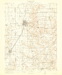
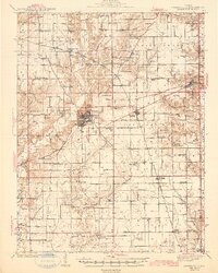
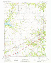
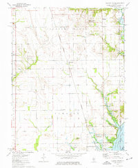
(106)- 1906 Map of Breese, 1958 Print
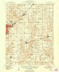
 1906 Breese1958 Print · USGSThe Illinois prairie east of St. Louis is shown here at the turn of the century, when rail lines and rural school districts formed the backbone of local life. Genealogy researchers can locate dozens of country schools like Linden School and Ruth School near established towns like Breese and Germantown.
 - 1907 Map of Breese
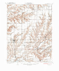
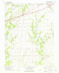
 1907 Breese1907 Print · USGSClinton and St. Clair counties were a bustling network of rail-towns and rural school districts at the turn of the century. Researchers can trace ancestral property near dozens of family-named landmarks like Richter School, McKee School, or the small village of Damiansville.2 unique versions available
 - 1910 Map of Carlyle
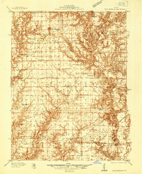
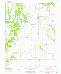
 1910 Carlyle1910 Print · USGSClinton County and the Kaskaskia River valley are captured here at a peak of rural development in the Edwardian era. Genealogists can trace a dense network of family-named landmarks including Hull School, McKendree Chapel, and the river crossing at Colmers Ferry.2 unique versions available
 - 1915 Map of Mount Olive
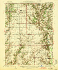
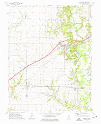
 1915 Mount Olive1915 Print · USGSCentral Illinois at the height of the steam era reveals a landscape shaped by competing railroads and dense rural school districts. Genealogists can trace family footprints through numerous local landmarks like Ritchie School, Robbs Mound, and the many lines of the Illinois Traction.3 unique versions available
 - 1932 Map of Greenville
 1932 Greenville1932 Print · USGSThis Illinois landscape in the early thirties reveals a bustling agricultural and rail network centered on Greenfield. Genealogists can trace family roots through numerous country burial grounds like Stultz Cem and historic schools such as Oakland Sch.
 - 1937 Map of New Douglas
 1937 New Douglas1937 Print · USGSMadison and Bond counties are seen here in the late 1930s, showing a high density of rural schools and family cemeteries. Researchers can trace the grounds of Mt Calvary Sch, locate the St Vincent Cem, or follow the Shoal Creek bottomlands.2 unique versions available
 - 1939 Map of Greenville, 1957 Print
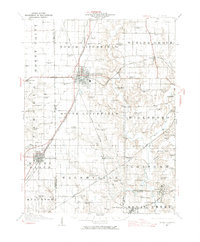
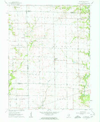
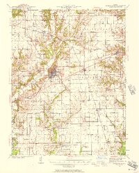 1939 Greenville1957 Print · USGSBond County and the surrounding prairies are captured here in the late thirties, showing a rural economy built on the Pennsylvania railroad and local post offices. Trace the sites of vanished schoolhouses like Pleasant View Sch and old burial grounds such as Dunkard Cem or Mt Moriah Cem.2 unique versions available
 - 1943 Map of Greenville
 1943 Greenville1943 Print · USGSBond County's rail-and-river network is fully detailed in the early 1940s, showing the intersection of major lines through the region. Researchers can trace family roots at Dunkard Cem or locate community hubs like Wisetown Beaver Creek P O and the CCC Camp.2 unique versions available
 - 1944 Map of New Douglas
 1944 New Douglas1944 Print · USGSMadison and Bond Counties are seen here during the mid-1930s, showing a well-established network of prairie farming communities and rail lines. Genealogists can locate dozens of named rural schools and cemeteries, from St Vincent Cem to the Hedgebound Sch and the village of Grantfork.2 unique versions available
 - 1944 Map of Mount Olive, 1965 Print
 1944 Mount Olive1965 Print · USGSCentral Illinois during the mid-forties reveals a landscape defined by industrial rail junctions and dozens of rural school districts. Genealogists can locate family-named landmarks like Hardenburg School, Ware Grove School, and the community of Walshville along the Chicago and Northwestern tracks.
 - 1947 Map of Hillsboro, 1963 Print
 1947 Hillsboro1963 Print · USGSMid-century Montgomery County centers on the rail and water networks around Hillsboro and Coffeen. Local historians can trace dozens of rural landmarks, from the County Farm and Sycamore School to small family plots like McCord Cem and Taylor Cem.
 - 1948 Map of Carlyle
 1948 Carlyle1948 Print · USGSCarlyle and the Kaskaskia River valley are captured in the late 1940s, showing a landscape of river-bend lakes and thriving rail towns. Researchers can trace the heritage of local families at McKendree Chapel, The Mound School, and the State Fish Hatchery.
 - 1949 Map of Hillsboro
 1949 Hillsboro1949 Print · USGSMontgomery County in the late 1940s is captured here at a peak of rail-driven industry and small-town growth. Genealogists and historians can trace the many rural schools and family cemeteries that dotted the landscape, from Taylor Springs to Fillmore and the Shiloh Ch.2 unique versions available
 - 1958 Map of Decatur, 1971 Print
 1958 Decatur1971 Print · USGSCentral Illinois in the mid-twentieth century shows a landscape defined by industrial rail hubs and the creation of large reservoirs. Researchers can trace historic corridors like the Penn Central or locate landmarks such as Lincoln Log Cabin State Park and Lake Springfield.3 unique versions available
 - 1958 Map of Belleville, 1973 Print
 1958 Belleville1973 Print · USGSSouthern Illinois during the mid-twentieth century reveals a landscape of industrial growth and massive new reservoirs. Genealogists and historians can trace the paths of the Illinois Central RR through towns like Centralia or locate landmarks such as Emerald Mound and the Looking Glass Prairie.3 unique versions available
 - 1961 Map of Decatur
 1961 Decatur1961 Print · USGSCentral Illinois in the late fifties was a bustling corridor of rail lines and prairie commerce centered on the state capital. Genealogists and historians can trace the intricate connections between Springfield, Decatur, and dozens of smaller settlements like Nokomis and Arcola.2 unique versions available
 - 1962 Map of Belleville
 1962 Belleville1962 Print · USGSSouthern Illinois in the late fifties reveals a landscape of industrial growth and ancient landmarks before the full expansion of the interstate system. Genealogists can trace family names and rural post offices near Centralia, Salem, and the historic Monks Mound.
 - 1962 Map of St. Rose, 1963 Print
 1962 St. Rose1963 Print · USGSThe rural borderlands of Clinton and Madison counties are captured here in the early sixties. Researchers can locate the Lake Branch Cemetery, the small cluster of Sebastopol, and early property lines near Shoal Creek.2 unique versions available
 - 1968 Map of Stolletown, 1971 Print
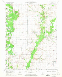 1968 Stolletown1971 Print · USGSClinton County during the late 1960s was a landscape where traditional farming met the growing energy industry and new water management projects. Researchers can locate family landmarks like St Peters Cem, the local Ford Sch, and the emerging Carlyle Reservoir.
 - 1969 Map of Keyesport, 1971 Print
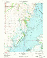 1969 Keyesport1971 Print · USGSThe Kaskaskia River valley in the late sixties reveals a landscape shaped by the new reservoir and recreational growth. Genealogists and local historians can locate McKendree Cem, trace the Burlington Northern line, and see the Keyesport Oil Field.2 unique versions available
 - 1974 Map of Mulberry Grove, 1977 Print
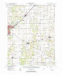
 1974 Mulberry Grove1977 Print · USGSBond County enters a new era of travel in the mid-seventies as the modern interstate begins to dominate the landscape near Mulberry Grove. Genealogists and local historians can locate many small burial sites like Dunkard Cem and trace the impact of Governor Bond Lake on old farmsteads.2 unique versions available
 - 1974 Map of Beaver Creek, 1977 Print
 1974 Beaver Creek1977 Print · USGSBond County's rural townships are documented here during the mid-seventies as traditional farming life coexisted with modern infrastructure. Researchers can trace the layout of old communities like Stubblefield and Dudleyville or locate family sites such as Greene Cem and Campground Ch.
 - 1974 Map of New Douglas, 1977 Print
 1974 New Douglas1977 Print · USGSThe rural borderlands of Madison and Macoupin counties are captured here in the mid-1970s as a vital crossroads for the Illinois rail industry. Genealogists and local historians can trace the foundations of Alhambra and Binney, or locate rural burial sites like St Ubaldus Cem and St Vincent Cem.
 - 1974 Map of Pocahontas, 1977 Print
 1974 Pocahontas1977 Print · USGSPocahontas and the border of Bond and Madison counties are shown in the mid-seventies just as the regional energy and rail landscape was shifting. Genealogists can locate family burial sites like Robison Cem and trace the early footprint of Pierron.
 - 1974 Map of Pleasant Mound, 1977 Print
 1974 Pleasant Mound1977 Print · USGSBond County's agricultural heartland meets the expanding waters of the Kaskaskia basin during the mid-seventies. Genealogists and local historians can locate rural landmarks like Noffsinger Cem, the village of Hookdale, and the Tamalco rail siding.
Showing maps 1-25 of 106
Top cities of Bond County
- Greenville historical maps
- Pleasant Mound historical maps
- Pocahontas historical maps
- Tamalco historical maps
- Mulberry Grove historical maps
- Pierron historical maps
See more
Frequently asked questions
- What are the different types of historical maps available for Bond County?
- What is the oldest map of Bond County?
- Where can I purchase historical maps of Bond County for my home or office?
- Where can I download high-res historical maps of Bond County?
- Are there historical topographic maps available for Bond County?
- Is there historical aerial imagery available for Bond County?
- Where are historical maps of Bond County sourced from?