1940s Maps of Bond County, Illinois
Explore 6 historic maps of Bond County from the 1940s. These maps offer a rare glimpse into what life looked like during the 1940s — showing old roads, neighborhoods, homes, and landmarks that have changed or disappeared over time.
Whether you're researching your family's past, planning a metal detecting trip, or studying how Bond County's landscape evolved across the 1940s, these high-resolution maps are a powerful tool for exploring the history of this region.
- Focus on a specific era: All maps on this page are from the 1940s, giving you a focused view of this time period.
- See what’s changed: Compare century-old streets, trails, and buildings to today's modern landscape using overlays and satellite layers.
- Research with precision: Use these maps for genealogy, historical research, land use analysis, or educational projects.
- View, download, or print: Maps are fully viewable online in high resolution, and can be downloaded or printed for your own records.
Start exploring Bond County's history through authentic maps from the 1940s. This is your window into the past.
Bond County, IL maps
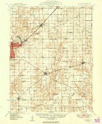
(6)- 1943 Map of Greenville
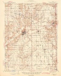 1943 Greenville1943 Print · USGSBond County's rail-and-river network is fully detailed in the early 1940s, showing the intersection of major lines through the region. Researchers can trace family roots at Dunkard Cem or locate community hubs like Wisetown Beaver Creek P O and the CCC Camp.2 unique versions available
 - 1944 Map of New Douglas
 1944 New Douglas1944 Print · USGSMadison and Bond Counties are seen here during the mid-1930s, showing a well-established network of prairie farming communities and rail lines. Genealogists can locate dozens of named rural schools and cemeteries, from St Vincent Cem to the Hedgebound Sch and the village of Grantfork.2 unique versions available
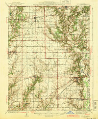
 - 1944 Map of Mount Olive, 1965 Print
 1944 Mount Olive1965 Print · USGSCentral Illinois during the mid-forties reveals a landscape defined by industrial rail junctions and dozens of rural school districts. Genealogists can locate family-named landmarks like Hardenburg School, Ware Grove School, and the community of Walshville along the Chicago and Northwestern tracks.
 - 1947 Map of Hillsboro, 1963 Print
 1947 Hillsboro1963 Print · USGSMid-century Montgomery County centers on the rail and water networks around Hillsboro and Coffeen. Local historians can trace dozens of rural landmarks, from the County Farm and Sycamore School to small family plots like McCord Cem and Taylor Cem.
 - 1948 Map of Carlyle
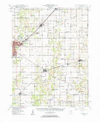
 1948 Carlyle1948 Print · USGSCarlyle and the Kaskaskia River valley are captured in the late 1940s, showing a landscape of river-bend lakes and thriving rail towns. Researchers can trace the heritage of local families at McKendree Chapel, The Mound School, and the State Fish Hatchery.
 - 1949 Map of Hillsboro
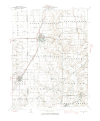
 1949 Hillsboro1949 Print · USGSMontgomery County in the late 1940s is captured here at a peak of rail-driven industry and small-town growth. Genealogists and historians can trace the many rural schools and family cemeteries that dotted the landscape, from Taylor Springs to Fillmore and the Shiloh Ch.2 unique versions available
End of results
Showing maps 1-6 of 6
Top cities of Bond County
- Greenville historical maps
- Pleasant Mound historical maps
- Pocahontas historical maps
- Tamalco historical maps
- Mulberry Grove historical maps
- Pierron historical maps
See more
Frequently asked questions
- What are the different types of historical maps available for Bond County?
- What is the oldest map of Bond County?
- Where can I purchase historical maps of Bond County for my home or office?
- Where can I download high-res historical maps of Bond County?
- Are there historical topographic maps available for Bond County?
- Is there historical aerial imagery available for Bond County?
- Where are historical maps of Bond County sourced from?