1940s Maps of Bureau County, Illinois
Explore 4 historic maps of Bureau County from the 1940s. These maps offer a rare glimpse into what life looked like during the 1940s — showing old roads, neighborhoods, homes, and landmarks that have changed or disappeared over time.
Whether you're researching your family's past, planning a metal detecting trip, or studying how Bureau County's landscape evolved across the 1940s, these high-resolution maps are a powerful tool for exploring the history of this region.
- Focus on a specific era: All maps on this page are from the 1940s, giving you a focused view of this time period.
- See what’s changed: Compare century-old streets, trails, and buildings to today's modern landscape using overlays and satellite layers.
- Research with precision: Use these maps for genealogy, historical research, land use analysis, or educational projects.
- View, download, or print: Maps are fully viewable online in high resolution, and can be downloaded or printed for your own records.
Start exploring Bureau County's history through authentic maps from the 1940s. This is your window into the past.
Bureau County, IL maps
(4)- 1944 Map of Kewanee
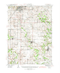 1944 Kewanee1944 Print · USGSHenry and Stark Counties in the 1940s show a landscape of thriving rail towns and closely spaced country schoolhouses. Genealogists can locate family-named landmarks like Cavanagh Cem and Bumble Bee Sch along the Spoon River valley.3 unique versions available
 - 1945 Map of Bradford
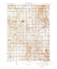 1945 Bradford1945 Print · USGSSettlement and agriculture in Stark and Bureau Counties reached a peak of rural infrastructure in the mid-1940s. Genealogists can trace family footprints across dozens of country school sites like Osceola Center Sch and churches such as Willow Springs Ch.3 unique versions available
 - 1947 Map of La Salle, 1958 Print
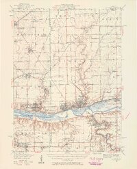 1947 La Salle1958 Print · USGSLa Salle and the Illinois River valley are shown here in the years following the war, as the rail-to-river economy remained in full swing. Local historians can trace the transition from rail to road while locating St Bedes College, Matthiessen Park, and Spring Valley.2 unique versions available
 - 1949 Map of Walnut
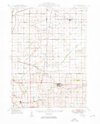 1949 Walnut1949 Print · USGSThe rural landscapes of Bureau and Lee counties are captured in the late 1940s, a time when one-room schools and small rail towns anchored the prairie. Genealogists can trace family landmarks like Bowen Cem, Sturtz Sch, and the community of New Bedford along the Green River.3 unique versions available
End of results
Showing maps 1-4 of 4
Top cities of Bureau County
- Princeton historical maps
- Spring Valley historical maps
- Walnut historical maps
- Ladd historical maps
- Sheffield historical maps
- Wyanet historical maps
See more
Frequently asked questions
- What are the different types of historical maps available for Bureau County?
- What is the oldest map of Bureau County?
- Where can I purchase historical maps of Bureau County for my home or office?
- Where can I download high-res historical maps of Bureau County?
- Are there historical topographic maps available for Bureau County?
- Is there historical aerial imagery available for Bureau County?
- Where are historical maps of Bureau County sourced from?