1970s Maps of Calhoun County, Illinois
Explore 9 historic maps of Calhoun County from the 1970s. These maps offer a rare glimpse into what life looked like during the 1970s — showing old roads, neighborhoods, homes, and landmarks that have changed or disappeared over time.
Whether you're researching your family's past, planning a metal detecting trip, or studying how Calhoun County's landscape evolved across the 1970s, these high-resolution maps are a powerful tool for exploring the history of this region.
- Focus on a specific era: All maps on this page are from the 1970s, giving you a focused view of this time period.
- See what’s changed: Compare century-old streets, trails, and buildings to today's modern landscape using overlays and satellite layers.
- Research with precision: Use these maps for genealogy, historical research, land use analysis, or educational projects.
- View, download, or print: Maps are fully viewable online in high resolution, and can be downloaded or printed for your own records.
Start exploring Calhoun County's history through authentic maps from the 1970s. This is your window into the past.
Calhoun County, IL maps
(9)- 1975 Map of Foley, 1978 Print
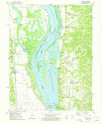 1975 Foley1978 Print · USGSThe riverfront communities of Missouri and Illinois are captured here in the mid-seventies, centered on the crossing between Foley and Batchtown. Genealogists can locate family burial sites at Stonebraker Cem and Plummer Cem or trace the old Burlington Northern rail line.
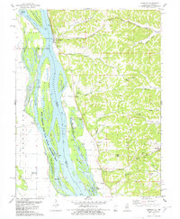
 - 1975 Map of Nutwood, 1978 Print
 1975 Nutwood1978 Print · USGSAlong the Illinois River in the mid-seventies, this survey reveals the dense backwaters and bluff-side communities of Jersey and Calhoun counties. Researchers can trace family sites near Nutwood and Rosedale, or locate recreational camps like Camp Piasa and Camp Potawatomi.
 - 1978 Map of Clarksville
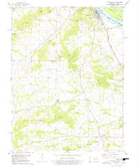 1978 Clarksville1978 Print · USGSThe Mississippi River bluffs in Pike County are shown here in the late seventies as the river-and-rail economy shaped the landscape. Researchers can trace local history through features like Lock and Dam No 24, Clopton Sch, and family-named landmarks like Ben Watts Knob.2 unique versions available
 - 1978 Map of Hamburg
 1978 Hamburg1978 Print · USGSThe Illinois-Missouri borderlands along the Mississippi come into focus during the late seventies, showing the river’s complex channel and the steep bluff country. Trace historical river crossings at Hamburg Ferry and explore local landmarks like Indian Creek Ch and Sugar Loaf.
 - 1978 Map of Pleasant Hill West
 1978 Pleasant Hill West1978 Print · USGSIn the mid-1970s, the Mississippi River bottomlands were a complex mix of wildlife refuges and rail-driven settlements. You can trace family roots at Wells Cem or explore the river infrastructure near Pleasant Hill and Atlas.2 unique versions available
 - 1978 Map of Annada
 1978 Annada1978 Print · USGSThe Mississippi River borderlands in the late 1970s reveal a detailed view of floodplain conservation and river-rail transport. Trace the path of the Burlington Northern through Annada or explore the backwaters of Slim Chute and Merida Lake.
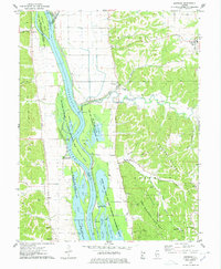
 - 1978 Map of Hardin
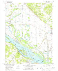
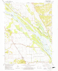
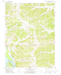
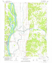 1978 Hardin1978 Print · USGSIn the late seventies, the Illinois River valley near Hardin remained a mosaic of backwater chutes and agricultural ridges. Genealogists can trace family names at Reddish Bridge or search for burial sites at Gunterman Cem and Clark Cem.
 - 1978 Map of Pleasant Dale Valley
 1978 Pleasant Dale Valley1978 Print · USGSThe Illinois river bluffs and Mississippi bottomlands come alive in the late seventies, showing a landscape defined by deep hollows and river islands. Genealogists can locate family names at Hillcrest Cemetery and Spear Cemetery or trace the rural reach of Mozier Landing.
 - 1978 Map of Pleasant Hill East
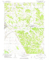 1978 Pleasant Hill East1978 Print · USGSPike and Calhoun Counties come into focus in the late 1970s as agricultural life meets the rugged ridge-and-valley terrain. Genealogists can locate family landmarks like Mason Cemetery or Carrollton Ridge Church while tracing the ILLINOIS CENTRAL GULF rail line.
End of results
Showing maps 1-9 of 9
Top cities of Calhoun County
- Hardin historical maps
- Kampsville historical maps
- Batchtown historical maps
- Brussels historical maps
- Hamburg historical maps
Frequently asked questions
- What are the different types of historical maps available for Calhoun County?
- What is the oldest map of Calhoun County?
- Where can I purchase historical maps of Calhoun County for my home or office?
- Where can I download high-res historical maps of Calhoun County?
- Are there historical topographic maps available for Calhoun County?
- Is there historical aerial imagery available for Calhoun County?
- Where are historical maps of Calhoun County sourced from?