1980s Maps of Calhoun County, Illinois
Explore 5 historic maps of Calhoun County from the 1980s. These maps offer a rare glimpse into what life looked like during the 1980s — showing old roads, neighborhoods, homes, and landmarks that have changed or disappeared over time.
Whether you're researching your family's past, planning a metal detecting trip, or studying how Calhoun County's landscape evolved across the 1980s, these high-resolution maps are a powerful tool for exploring the history of this region.
- Focus on a specific era: All maps on this page are from the 1980s, giving you a focused view of this time period.
- See what’s changed: Compare century-old streets, trails, and buildings to today's modern landscape using overlays and satellite layers.
- Research with precision: Use these maps for genealogy, historical research, land use analysis, or educational projects.
- View, download, or print: Maps are fully viewable online in high resolution, and can be downloaded or printed for your own records.
Start exploring Calhoun County's history through authentic maps from the 1980s. This is your window into the past.
Calhoun County, IL maps
(5)- 1980 Map of Kampsville, 1981 Print
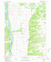 1980 Kampsville1981 Print · USGSThe Illinois River valley in the early 1980s reveals a landscape defined by historic landings and limestone bluffs. Genealogists can trace family roots through several sites like St Anselm Cem and Eldred Mem Gardens, or locate old industrial landmarks such as the Schumann Quarry.
 - 1980 Map of Pearl East, 1981 Print
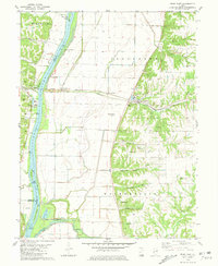 1980 Pearl East1981 Print · USGSGreene County bottomlands and bluffs come alive in this early 1980s survey of the Illinois River valley. Genealogists can trace family burial sites like Likely Cem and Kinser Cem while historians follow the Illinois Central Gulf rail line through Hillview.
 - 1980 Map of Pearl West, 1981 Print
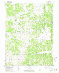 1980 Pearl West1981 Print · USGSThe Pike and Calhoun county line comes alive in this late twentieth-century study of the ridges and hollows near the Illinois River. Genealogists and historians can trace family ties at McConnell Cem and Hess Cem or locate the site of Old Pearl.
 - 1985 Map of St Louis
 1985 St Louis1985 Print · USGSThe St. Louis metropolitan area and its river confluences are captured here during a period of significant suburban expansion in the 1980s. Genealogists and historians can trace the development of older neighborhoods and landmarks like Jefferson Barracks, Cahokia Mounds State Park, and Washington University.3 unique versions available
 - 1985 Map of Jerseyville
 1985 Jerseyville1985 Print · USGSThe confluence of the Illinois and Mississippi rivers defines this 1980s landscape of fertile bottomlands and rail-hub towns. Genealogists and historians can trace the foundations of communities like Jerseyville and White Hall alongside the Oak Grove Cem and St Mary Church.2 unique versions available
End of results
Showing maps 1-5 of 5
Top cities of Calhoun County
- Hardin historical maps
- Kampsville historical maps
- Batchtown historical maps
- Brussels historical maps
- Hamburg historical maps
Frequently asked questions
- What are the different types of historical maps available for Calhoun County?
- What is the oldest map of Calhoun County?
- Where can I purchase historical maps of Calhoun County for my home or office?
- Where can I download high-res historical maps of Calhoun County?
- Are there historical topographic maps available for Calhoun County?
- Is there historical aerial imagery available for Calhoun County?
- Where are historical maps of Calhoun County sourced from?