1990s Maps of Calhoun County, Illinois
Explore 10 historic maps of Calhoun County from the 1990s. These maps offer a rare glimpse into what life looked like during the 1990s — showing old roads, neighborhoods, homes, and landmarks that have changed or disappeared over time.
Whether you're researching your family's past, planning a metal detecting trip, or studying how Calhoun County's landscape evolved across the 1990s, these high-resolution maps are a powerful tool for exploring the history of this region.
- Focus on a specific era: All maps on this page are from the 1990s, giving you a focused view of this time period.
- See what’s changed: Compare century-old streets, trails, and buildings to today's modern landscape using overlays and satellite layers.
- Research with precision: Use these maps for genealogy, historical research, land use analysis, or educational projects.
- View, download, or print: Maps are fully viewable online in high resolution, and can be downloaded or printed for your own records.
Start exploring Calhoun County's history through authentic maps from the 1990s. This is your window into the past.
Calhoun County, IL maps
(10)- 1990 Map of Brussels, 1995 Print
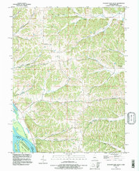
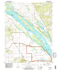
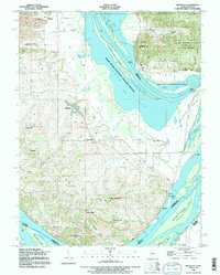 1990 Brussels1995 Print · USGSThe tip of the Calhoun County peninsula comes into focus as it was in the early 1990s, where the great river systems converge. Genealogists and river historians can trace family landings and rural hamlets like Brussels, Golden Eagle, and St Josephs Ch.
 - 1990 Map of Grafton, 1995 Print
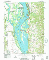
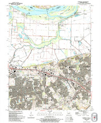
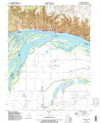 1990 Grafton1995 Print · USGSThe rivers of Illinois and Missouri meet at the turn of the 1990s in a landscape of dramatic bluffs and expansive floodplains. Researchers can trace the riverfront at Grafton, explore the ravines of Pere Marquette State Park, and locate rural landmarks like Orchard Farm or Scenic Hill Cem.
 - 1993 Map of Winfield, 1996 Print
 1993 Winfield1996 Print · USGSThe confluence of the Mississippi and Cuivre Rivers is captured in the early 1990s, showing a rich landscape of river landings and floodplain lakes. Trace the ferry at West Point Ferry or locate family sites at Ingle Cem and Minesinger Cem.
 - 1993 Map of Hamburg, 1996 Print
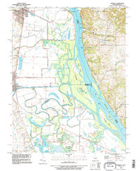
 1993 Hamburg1996 Print · USGSThe Mississippi River valley and the bluffs of Calhoun County are captured here in the 1990s as a landscape of rural hamlets and complex wetlands. Researchers can locate remote family burial grounds like Mt Hope Cem and trace historic river access points such as Old Westport Landing or Norton Woods Public Access.
 - 1993 Map of Pleasant Dale Valley, 1996 Print
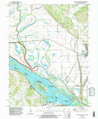
 1993 Pleasant Dale Valley1996 Print · USGSThe confluence of the Mississippi and Illinois Rivers defines this pocket of Calhoun County in the 1990s. Genealogists and local historians can trace family plots at Hillcrest Cem or Silver Creek Cem and explore the riverbank geography of Mozier and Cliffdale.
 - 1993 Map of Foley, 1996 Print
 1993 Foley1996 Print · USGSThe Mississippi River bottoms and Illinois bluffs are captured here in the early nineties, showing the Missouri-Illinois border before modern developments. Local historians can trace river-town life through Parkers Landing, St Barbara Cem, and the river works at Lock and Dam No 25.
 - 1993 Map of Pleasant Hill West, 1996 Print
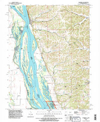
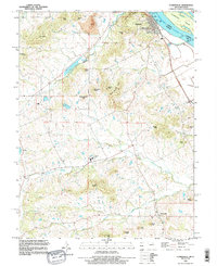
 1993 Pleasant Hill West1996 Print · USGSThe Illinois-Missouri borderlands appear in the mid-1990s as a highly engineered landscape of river islands, sloughs, and levees. Researchers can trace family history at Martinsburg Cem or study river navigation at Lock and Dam No 24 and The Sny.
 - 1993 Map of Clarksville, 1996 Print
 1993 Clarksville1996 Print · USGSThe Mississippi River bluffs in the 1990s show a mix of river engineering and rugged upland settlements. Researchers can locate family landmarks like Ben Watts Knob, the rural community of Paynesville, and river features such as Lock and Dam No 24.
 - 1993 Map of Annada, 1996 Print
 1993 Annada1996 Print · USGSThe Mississippi River borderlands of Pike County are captured here in the early nineties, showing a landscape of conservation and flood control. Genealogists and local historians can trace the foundations of Annada, Kissenger, and the Lang Cem alongside the complex waterways of The Sny and SLIM CHUTE.
 - 1994 Map of Kampville, 1995 Print
 1994 Kampville1995 Print · USGSThe Missouri riverfront near St. Charles shows a landscape of agricultural levees and rapid suburban growth in the mid-1990s. Trace old river landings like McCann Landing, the route of the Katy Trail State Park, and the Golden Eagle Ferry.
End of results
Showing maps 1-10 of 10
Top cities of Calhoun County
- Hardin historical maps
- Kampsville historical maps
- Batchtown historical maps
- Brussels historical maps
- Hamburg historical maps
Frequently asked questions
- What are the different types of historical maps available for Calhoun County?
- What is the oldest map of Calhoun County?
- Where can I purchase historical maps of Calhoun County for my home or office?
- Where can I download high-res historical maps of Calhoun County?
- Are there historical topographic maps available for Calhoun County?
- Is there historical aerial imagery available for Calhoun County?
- Where are historical maps of Calhoun County sourced from?