1980s Maps of Mount Carroll, Illinois
Explore 2 historic maps of Mount Carroll from the 1980s. These maps offer a rare glimpse into what life looked like during the 1980s — showing old roads, neighborhoods, homes, and landmarks that have changed or disappeared over time.
Whether you're researching your family's past, planning a metal detecting trip, or studying how Mount Carroll's landscape evolved across the 1980s, these high-resolution maps are a powerful tool for exploring the history of this region.
- Focus on a specific era: All maps on this page are from the 1980s, giving you a focused view of this time period.
- See what’s changed: Compare century-old streets, trails, and buildings to today's modern landscape using overlays and satellite layers.
- Research with precision: Use these maps for genealogy, historical research, land use analysis, or educational projects.
- View, download, or print: Maps are fully viewable online in high resolution, and can be downloaded or printed for your own records.
Start exploring Mount Carroll's history through authentic maps from the 1980s. This is your window into the past.
Mount Carroll, IL maps
(2)- 1981 Map of Rockford
 1981 Rockford1981 Print · USGSNorthern Illinois during the early eighties shows a landscape shaped by river valleys and a maturing rail network. Genealogists can trace family roots through settlements like Morseville and Buckhorn Corners while exploring the Rock River valley.2 unique versions available
 - 1985 Map of Mt. Carroll, 1986 Print
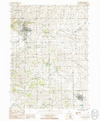 1985 Mt. Carroll1986 Print · USGSCarroll County agriculture and small-town life are captured here in the mid-eighties as industry shifted and old townships remained. Researchers can pinpoint family-named landmarks and infrastructure like Timber Lake, the Inactive Quarry near Johnson Creek, and the street grids of Mt Carroll.
End of results
Showing maps 1-2 of 2
Top cities near Mount Carroll
- Clinton historical maps
- Fulton historical maps
- Savanna historical maps
- Lanark historical maps
- Loran historical maps
- Milledgeville historical maps
See more
Frequently asked questions
- What are the different types of historical maps available for Mount Carroll?
- What is the oldest map of Mount Carroll?
- Where can I purchase historical maps of Mount Carroll for my home or office?
- Where can I download high-res historical maps of Mount Carroll?
- Are there historical topographic maps available for Mount Carroll?
- Is there historical aerial imagery available for Mount Carroll?
- Where are historical maps of Mount Carroll sourced from?