1940s Maps of Cook County, Illinois
Explore 6 historic maps of Cook County from the 1940s. These maps offer a rare glimpse into what life looked like during the 1940s — showing old roads, neighborhoods, homes, and landmarks that have changed or disappeared over time.
Whether you're researching your family's past, planning a metal detecting trip, or studying how Cook County's landscape evolved across the 1940s, these high-resolution maps are a powerful tool for exploring the history of this region.
- Focus on a specific era: All maps on this page are from the 1940s, giving you a focused view of this time period.
- See what’s changed: Compare century-old streets, trails, and buildings to today's modern landscape using overlays and satellite layers.
- Research with precision: Use these maps for genealogy, historical research, land use analysis, or educational projects.
- View, download, or print: Maps are fully viewable online in high resolution, and can be downloaded or printed for your own records.
Start exploring Cook County's history through authentic maps from the 1940s. This is your window into the past.
Cook County, IL maps
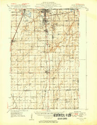
(6)- 1940 Map of Elgin, 1957 Print
 1940 Elgin1957 Print · USGSKane and McHenry Counties at the start of the 1940s reveal a landscape of bustling river towns and quiet prairie schools. Researchers can trace family roots through numerous local landmarks like Munshawville School, the State Hospital, and the rail junction at Huntley.
 - 1948 Map of Wheaton, 1956 Print
 1948 Wheaton1956 Print · USGSDuPage County at the dawn of the post-war boom shows a landscape of growing towns connected by a dense network of steam and electric rails. Researchers can trace the early footprints of Naperville, Wheaton, and Downers Grove alongside smaller stops like Ontarioville and Eola.
 - 1948 Map of Geneva, 1964 Print
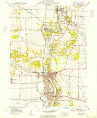
 1948 Geneva1964 Print · USGSThe Fox River valley thrives in the late 1940s, showing the industrial cores of Geneva and Batavia before the suburban boom. Trace the complex rail network through Elburn and St Charles, or locate rural landmarks like Johnsons Mound and Red Brick Sch.
 - 1949 Map of Peotone
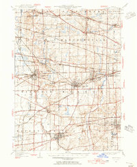
 1949 Peotone1949 Print · USGSWill County’s rural townships are captured in the late 1940s, a period of transition for its railroad hubs and farming communities. Genealogists can locate family-named landmarks and country schools like Fivemile Grove Sch, Pfundstein Sch, and the St Peter Cem.2 unique versions available
 - 1949 Map of Geneva
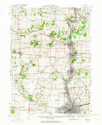
 1949 Geneva1949 Print · USGSThe Fox River valley in the late 1940s reveals a unique landscape of riverside industrial towns and massive state institutions. Genealogists and local historians can trace the footprint of the State Boys School, find Dunham Castle, or locate rural landmarks like Burr School.2 unique versions available
 - 1949 Map of Crete
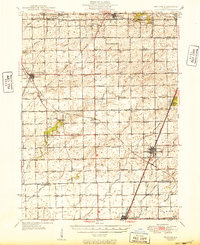
 1949 Crete1949 Print · USGSWill County and the surrounding borderlands are captured here in the late 1940s as a busy intersection of rail and road. Genealogists can locate dozens of country schools and churches like Beebe Grove Sch, St Annes Ch, and Crete Cem.
End of results
Showing maps 1-6 of 6
Top cities of Cook County
- Chicago historical maps
- Cicero historical maps
- Arlington Heights historical maps
- Evanston historical maps
- Des Plaines historical maps
- Berwyn historical maps
See more
Frequently asked questions
- What are the different types of historical maps available for Cook County?
- What is the oldest map of Cook County?
- Where can I purchase historical maps of Cook County for my home or office?
- Where can I download high-res historical maps of Cook County?
- Are there historical topographic maps available for Cook County?
- Is there historical aerial imagery available for Cook County?
- Where are historical maps of Cook County sourced from?