1950s Maps of Cook County, Illinois
Explore 37 historic maps of Cook County from the 1950s. These maps offer a rare glimpse into what life looked like during the 1950s — showing old roads, neighborhoods, homes, and landmarks that have changed or disappeared over time.
Whether you're researching your family's past, planning a metal detecting trip, or studying how Cook County's landscape evolved across the 1950s, these high-resolution maps are a powerful tool for exploring the history of this region.
- Focus on a specific era: All maps on this page are from the 1950s, giving you a focused view of this time period.
- See what’s changed: Compare century-old streets, trails, and buildings to today's modern landscape using overlays and satellite layers.
- Research with precision: Use these maps for genealogy, historical research, land use analysis, or educational projects.
- View, download, or print: Maps are fully viewable online in high resolution, and can be downloaded or printed for your own records.
Start exploring Cook County's history through authentic maps from the 1950s. This is your window into the past.
Cook County, IL maps
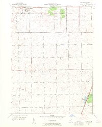
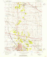
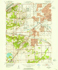
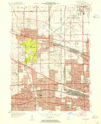
(37)- 1951 Map of Highland Park
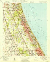 1951 Highland Park1951 Print · USGSThe Illinois North Shore thrived in the early fifties as a landscape of prestigious clubs, military outposts, and growing suburbs. Genealogists and historians can trace the footprints of Fort Sheridan, Sky Harbor Airport, and the vanished Brickyard near Northbrook.2 unique versions available
 - 1953 Map of Tinley Park, 1955 Print
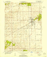 1953 Tinley Park1955 Print · USGSThe Cook and Will County border areas are shown here during the early fifties growth of Tinley Park and Orland Park. Researchers can find family-named landmarks like Hickory Cem and long-standing schools such as Summit Hill Sch and Kirby Sch.
 - 1953 Map of Arlington Heights, 1955 Print
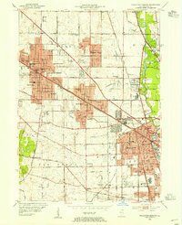 1953 Arlington Heights1955 Print · USGSPost-war Cook County comes alive in this survey of the growing corridor from Arlington Heights to Des Plaines. Trace family roots at All Saints Cem or locate the early footprints of Pal-Waukee Airport and O'Hare Field.
 - 1953 Map of Mokena, 1955 Print
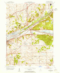
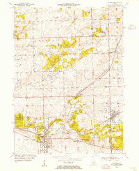 1953 Mokena1955 Print · USGSWill County's agricultural heartland is captured mid-century as the rail-centered towns of Mokena and New Lenox began to expand. Genealogists and historians can locate numerous rural landmarks, including St Johns Cem, the Wabash railroad, and Wells Corner Sch.
 - 1953 Map of Steger, 1955 Print
 1953 Steger1955 Print · USGSSouthern Cook and Will Counties are shown in the early fifties as new suburban developments began to reshape the prairie landscape. Genealogists can trace family roots through numerous local landmarks, including Lincoln Fields Sta, Adams Cem, and the Sauk Trail Sch.4 unique versions available
 - 1953 Map of Highland Park, 1955 Print
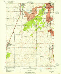
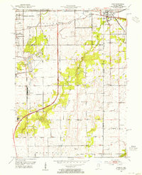
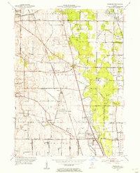
 1953 Highland Park1955 Print · USGSThe North Shore was in the midst of post-war expansion when this survey was updated, showing the growing suburbs between the lake and the forest preserves. Genealogists and local historians can locate Fort Sheridan, Mooney Cemetery, and the many country clubs that defined this era.
 - 1953 Map of Calumet City, 1955 Print
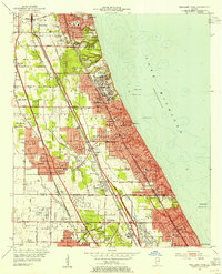
 1953 Calumet City1955 Print · USGSThe Calumet region during the early fifties shows a burgeoning industrial and suburban landscape spanning the Illinois Indiana state line. Trace the development of local neighborhoods and infrastructure from Chicago Hammond Airport to the Thornton Junction rail hub.
 - 1953 Map of Calumet Lake, 1955 Print
 1953 Calumet Lake1955 Print · USGSThe industrial corridor of the Chicago South Side and Northwest Indiana comes alive in this mid-century survey. Genealogists and historians can trace the footprint of neighborhoods like Pullman, Hegewisch, and Altgeld Gardens alongside the massive rail yards of the Pennsylvania Railroad.
 - 1953 Map of Harvey, 1955 Print
 1953 Harvey1955 Print · USGSSouthern Cook County experiences a mid-century suburban surge centered on the rail corridors of Harvey and Homewood. Genealogists and historians can trace family roots through numerous sites like the Oak Forest Infirmary, Markham Yard, and St Johns Sch.
 - 1953 Map of Frankfort, 1955 Print
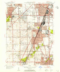
 1953 Frankfort1955 Print · USGSWill and Cook County farm country is captured here in the early fifties, before suburban expansion transformed the outskirts of Chicago. Researchers can trace rural lineages through numerous local sites including St Peters Cem, Rahm Sch (Abandoned), and the Green Garden Sch.4 unique versions available
 - 1953 Map of Dyer, 1955 Print
 1953 Dyer1955 Print · USGSThe Illinois-Indiana border during the early fifties reveals a landscape of growing suburbs and traditional crossroads. Researchers can trace historic family roots at Eagle Lake Cem or locate lost landmarks like Klemme Sch and Lincoln Fields.
 - 1953 Map of River Forest, 1955 Print
 1953 River Forest1955 Print · USGSSuburban Cook County is seen in a period of dense growth during the early fifties, showing the maturing street grids of River Grove and Oak Park. Genealogists can locate numerous local landmarks like St Joseph Cemetery and schools such as Wright Jr College.
 - 1953 Map of Evanston, 1955 Print
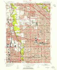
 1953 Evanston1955 Print · USGSThe North Shore suburbs and northern Chicago lakefront are captured in the mid-1950s as these rail-connected communities reached their peak maturity. Researchers can trace historic campus footprints at Northwestern University or locate family sites near Calvary Cemetery and New Trier High Sch.
 - 1953 Map of West Chicago, 1955 Print
 1953 West Chicago1955 Print · USGSThe rail corridors of DuPage County intersect at West Chicago in the early fifties, showing a landscape of small rural schools and emerging suburbs. Trace family history at the Old Ontarioville Cem or the Oak Glen Sch (Abandoned).
 - 1953 Map of Wheeling, 1955 Print
 1953 Wheeling1955 Print · USGSThe Lake County and Cook County borderlands appear here in the early fifties as the region's agricultural past meets a new era of aviation and speedways. Genealogists and local researchers can trace old crossroads like Aptakisic and Halfday or locate family sites at Vernon Cem and Tripp Sch.
 - 1953 Map of Lombard, 1955 Print
 1953 Lombard1955 Print · USGSDuPage County was undergoing rapid postwar growth when this mid-century survey was conducted, showing the expansion of towns along major rail lines. Researchers can find numerous parochial schools and cemeteries like Sacred Heart Sch, St Pauls Cem, and the historic Old Mill.
 - 1953 Map of Palatine, 1955 Print
 1953 Palatine1955 Print · USGSMid-century Cook County comes to life in the early 1950s as the rail corridor drives development between Palatine and Arlington Heights. Genealogists and local historians can trace early school sites like Sunderlage Sch and rural landmarks such as Mount Hope Cem and the Radio Station (WGN).
 - 1953 Map of Palos Park, 1955 Print
 1953 Palos Park1955 Print · USGSMid-century Cook County shows a landscape of expansive forest preserves and industrial waterways just as residential growth began to accelerate. Genealogists and local historians can trace family plots at Holy Sepulchre Cemetery or locate the long-since changed Harlem Airport and Bachelor Grove Cem.
 - 1953 Map of Sag Bridge, 1955 Print
 1953 Sag Bridge1955 Print · USGSThe Des Plaines River valley transitions from industrial canal corridors to preserved forest land in the early fifties. Genealogists and historians can locate family plots at Mount Vernon Memorial Park Cemetery and trace old school districts like Derby Sch and Trinity Sch.2 unique versions available
 - 1953 Map of Chicago Loop, 1956 Print
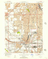
 1953 Chicago Loop1956 Print · USGSMid-century Chicago is captured here at a moment of significant infrastructure expansion and urban density. Genealogists and historians can trace neighborhood parish schools like St Michael High Sch, local cemeteries such as Rosehill Cemetery, and the rise of the Congress Street Expressway.
 - 1953 Map of Blue Island, 1956 Print
 1953 Blue Island1956 Print · USGSBlue Island and the southern Chicago suburbs are shown here in a period of significant postwar growth and heavy rail industrialization. Genealogists and local historians can trace the vast cemetery lands of Mt Greenwood Cemetery or find defunct landmarks like Howell Airport and the Rock Island RR lines.
 - 1953 Map of Jackson Park, 1956 Print
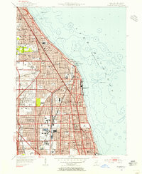
 1953 Jackson Park1956 Print · USGSThe South Side of Chicago and its lakefront are captured here in the early 1950s, showing a period of significant urban growth and shoreline development. Genealogists and historians can trace neighborhood landmarks from Oakwoods Cemetery to the University of Chicago and the aviation grounds of Meigs Field.
 - 1953 Map of Englewood, 1956 Print
 1953 Englewood1956 Print · USGSMid-century Southwest Chicago reveals a landscape defined by heavy industry and deep-rooted neighborhoods during the post-war era. Researchers can trace the massive rail infrastructure of the Indiana Harbor Belt and find local landmarks like Marquette Park and the US Quartermaster Depot.
 - 1953 Map of Park Ridge, 1956 Print
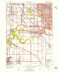
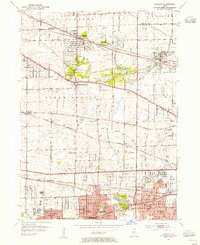
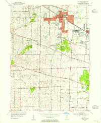
 1953 Park Ridge1956 Print · USGSThe northern Chicago suburbs are caught in a moment of rapid post-war suburbanization during the early fifties. Genealogists and local historians can trace family roots through numerous sites like Sunset Memorial Gardens, Maine Township High Sch, and the St Andrews Home.
 - 1953 Map of Elmhurst, 1956 Print
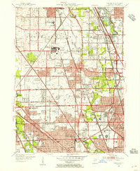
 1953 Elmhurst1956 Print · USGSThe western suburbs of Chicago are seen in a period of intense postwar expansion, from the rising O'Hare Field to the core of Elmhurst. Genealogists and historians can trace local institutions and early aviation sites like the Mater Dolorosa Seminary, Zion Cem, and Sky Haven Airport.
Showing maps 1-25 of 37
Top cities of Cook County
- Chicago historical maps
- Cicero historical maps
- Arlington Heights historical maps
- Evanston historical maps
- Des Plaines historical maps
- Berwyn historical maps
See more
Frequently asked questions
- What are the different types of historical maps available for Cook County?
- What is the oldest map of Cook County?
- Where can I purchase historical maps of Cook County for my home or office?
- Where can I download high-res historical maps of Cook County?
- Are there historical topographic maps available for Cook County?
- Is there historical aerial imagery available for Cook County?
- Where are historical maps of Cook County sourced from?