
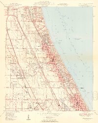
1951 Map of Highland Park
USGS Topo · Published 1951About this map
Fort Sheridan and its extensive military reservation dominate the Lake Michigan shoreline in this mid-century portrait of Chicago's North Shore. The suburban landscape is defined by a dense concentration of private leisure grounds, including the Onwentsia Club, Bob-O-Link Golf Club, and the famous Ravinia Park. Significant transportation and utility infrastructure support the growing communities of Highland Park, Lake Forest, and Glencoe, with the Chicago and North Western and Chicago North Shore and Milwaukee railroads running parallel to the coast. Inland, the North Branch of the Chicago River and its various forks, such as the Middle Fork, transition from natural watercourses into the engineered Skokie Lagoons. The presence of the Sky Harbor Airport and the US Coast Guard Radio Station highlights the era's specialized military and aviation footprint in Lake County.
Find a feature on this map
61 named features on this map. Tap any name to fly to it.
Don’t see what you’re looking for? This feature index may not catch every label — zoom into the map to look around manually.
Map Details
Editions of this 1951 Highland Park Map
2 editions found
Other maps of this area

1899 · Evanston
USGS Topo · 1:62,500

1900 · Highwood
USGS Topo · 1:62,500

1906 · Waukegan
USGS Topo · 1:62,500

1908 · Waukegan
USGS Topo · 1:62,500

1927 · Arlington Heights
USGS Topo · 1:24,000

1928 · Wheeling
USGS Topo · 1:24,000

1928 · Highland Park
USGS Topo · 1:24,000

1928 · Evanston
USGS Topo · 1:24,000

1929 · Park Ridge
USGS Topo · 1:24,000
1953 · Arlington Heights
USGS Topo · 1:24,000