1900s (20th Century) Maps of Dallas City, Illinois
Explore 9 historic maps of Dallas City from the 1900s (20th Century). These maps offer a rare glimpse into what life looked like during the 1900s — showing old roads, neighborhoods, homes, and landmarks that have changed or disappeared over time.
Whether you're researching your family's past, planning a metal detecting trip, or studying how Dallas City's landscape evolved across the 1900s, these high-resolution maps are a powerful tool for exploring the history of this region.
- Focus on a specific era: All maps on this page are from the 1900s, giving you a focused view of this time period.
- See what’s changed: Compare century-old streets, trails, and buildings to today's modern landscape using overlays and satellite layers.
- Research with precision: Use these maps for genealogy, historical research, land use analysis, or educational projects.
- View, download, or print: Maps are fully viewable online in high resolution, and can be downloaded or printed for your own records.
Start exploring Dallas City's history through authentic maps from the 1900s. This is your window into the past.
Dallas City, IL maps
(9)- 1932 Map of Lomax, 1957 Print
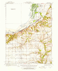 1932 Lomax1957 Print · USGSWestern Illinois river towns and railroad junctions thrive during the early 1930s as the river remains a central artery for commerce and life. Genealogists can trace family footprints across dozens of rural landmarks, including Dallas City, Gittings Mound, and the uniquely named Froggie Sch.
 - 1937 Map of Lomax
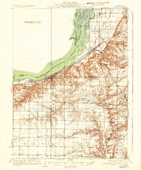 1937 Lomax1937 Print · USGSThe riverfront and rail corridors of Henderson and Hancock Counties come alive in the late 1930s, documenting a time of active country schools and river commerce. Genealogists can locate family landmarks like Gittings Cem, Enterprise Ch, and distinctively named sites like Shake Rag Sch.2 unique versions available
 - 1958 Map of Burlington, 1968 Print
 1958 Burlington1968 Print · USGSThe tri-state river country of Iowa, Illinois, and Missouri is captured here in the mid-fifties, dominated by the Mississippi River and major rail lines. Genealogists and historians can trace the development of river towns like Keokuk or locate the sprawling Iowa Army Ammunition Plant.4 unique versions available
 - 1961 Map of Burlington
 1961 Burlington1961 Print · USGSThe tri-state borderlands along the Mississippi River are captured here during the late fifties and early sixties, showing the vital river-and-rail economy of Iowa, Illinois, and Missouri. Genealogists and historians can trace the development of major hubs like Galesburg and Macomb alongside landmark sites such as the Iowa Ordnance Plant and the historic river town of Nauvoo.
 - 1963 Map of Burlington
 1963 Burlington1963 Print · USGSThe tri-state river country of the Mississippi and Illinois valleys comes alive in this mid-century survey. Genealogists and historians can trace the industrial and academic growth of the region, from the Iowa Ordnance Plant to campuses like Knox College and Western Illinois University.
 - 1964 Map of Colusa, 1965 Print
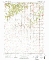 1964 Colusa1965 Print · USGSHancock County agriculture and rail life are captured here in the mid-1960s, showing the corridor of the Chicago Burlington and Quincy railroad. Genealogists can trace local roots through burial grounds like Harris Cem and the small settlements of Colusa and Adrian.2 unique versions available
 - 1964 Map of Dallas City, 1965 Print
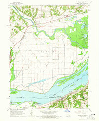 1964 Dallas City1965 Print · USGSThe Mississippi River floodplain in the 1960s reveals a landscape of industrial rail lines and intricate backwaters. Trace the historic tracks of the Atchison Topeka and Santa Fe or locate rural landmarks like Oak Grove Ch and Eureka Sch.4 unique versions available
 - 1985 Map of Burlington
 1985 Burlington1985 Print · USGSThe Tri-State region during the mid-eighties shows a landscape shaped by the Mississippi River and a dense network of railroads. Genealogists and local historians can trace family sites near Aspen Grove Cem or locate community landmarks in Burlington, Fort Madison, and Mount Pleasant.2 unique versions available
 - 1990 Map of Burlington
 1990 Burlington1990 Print · USGSThe tri-state confluence of Iowa, Illinois, and Missouri is mapped here at the end of the twentieth century. Genealogists and historians can trace the riverfront heritage of Burlington, Keokuk, and Fort Madison, or locate sites like the Battle of Athens State Historic Site.2 unique versions available
End of results
Showing maps 1-9 of 9
Top cities near Dallas City
- Burlington historical maps
- Fort Madison historical maps
- Keokuk historical maps
- West Burlington historical maps
- Carthage historical maps
- La Harpe historical maps
See more
Frequently asked questions
- What are the different types of historical maps available for Dallas City?
- What is the oldest map of Dallas City?
- Where can I purchase historical maps of Dallas City for my home or office?
- Where can I download high-res historical maps of Dallas City?
- Are there historical topographic maps available for Dallas City?
- Is there historical aerial imagery available for Dallas City?
- Where are historical maps of Dallas City sourced from?