1930s Maps of Douglas County, Illinois
Explore 2 historic maps of Douglas County from the 1930s. These maps offer a rare glimpse into what life looked like during the 1930s — showing old roads, neighborhoods, homes, and landmarks that have changed or disappeared over time.
Whether you're researching your family's past, planning a metal detecting trip, or studying how Douglas County's landscape evolved across the 1930s, these high-resolution maps are a powerful tool for exploring the history of this region.
- Focus on a specific era: All maps on this page are from the 1930s, giving you a focused view of this time period.
- See what’s changed: Compare century-old streets, trails, and buildings to today's modern landscape using overlays and satellite layers.
- Research with precision: Use these maps for genealogy, historical research, land use analysis, or educational projects.
- View, download, or print: Maps are fully viewable online in high resolution, and can be downloaded or printed for your own records.
Start exploring Douglas County's history through authentic maps from the 1930s. This is your window into the past.
Douglas County, IL maps
(2)- 1935 Map of Arcola
 1935 Arcola1935 Print · USGSCentral Illinois farming communities thrived along the Illinois Central and Pennsylvania rail lines in the 1930s. Genealogists can trace family roots through numerous rural landmarks like Yoder Cem, Quinn Chapel, and Pulltight Sch.3 unique versions available
 - 1936 Map of Oakland
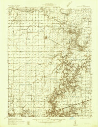 1936 Oakland1936 Print · USGSColes and Douglas Counties in the mid-1930s exhibit a landscape deeply connected by the Embarrass River and the Pennsylvania railroad. Genealogists can trace hundreds of small family landmarks, from Patsy Mitchell Cem to the scores of local schoolhouses like Boneset Sch and Seven Hickory Sch.5 unique versions available
End of results
Showing maps 1-2 of 2
Top cities of Douglas County
- Tuscola historical maps
- Arcola historical maps
- Villa Grove historical maps
- Newman historical maps
- Camargo historical maps
- Hindsboro historical maps
See more
Frequently asked questions
- What are the different types of historical maps available for Douglas County?
- What is the oldest map of Douglas County?
- Where can I purchase historical maps of Douglas County for my home or office?
- Where can I download high-res historical maps of Douglas County?
- Are there historical topographic maps available for Douglas County?
- Is there historical aerial imagery available for Douglas County?
- Where are historical maps of Douglas County sourced from?