1960s Maps of Edgar County, Illinois
Explore 11 historic maps of Edgar County from the 1960s. These maps offer a rare glimpse into what life looked like during the 1960s — showing old roads, neighborhoods, homes, and landmarks that have changed or disappeared over time.
Whether you're researching your family's past, planning a metal detecting trip, or studying how Edgar County's landscape evolved across the 1960s, these high-resolution maps are a powerful tool for exploring the history of this region.
- Focus on a specific era: All maps on this page are from the 1960s, giving you a focused view of this time period.
- See what’s changed: Compare century-old streets, trails, and buildings to today's modern landscape using overlays and satellite layers.
- Research with precision: Use these maps for genealogy, historical research, land use analysis, or educational projects.
- View, download, or print: Maps are fully viewable online in high resolution, and can be downloaded or printed for your own records.
Start exploring Edgar County's history through authentic maps from the 1960s. This is your window into the past.
Edgar County, IL maps
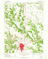
(11)- 1962 Map of Indianapolis
 1962 Indianapolis1962 Print · USGSCentral Indiana and the Illinois borderlands are captured here in the early sixties, showing the region's dense rail networks and growing urban centers. Genealogists and historians can locate family-named landmarks and institutions like Crown Hill Cem, Indiana University, and the Indianapolis Motor Speedway.
 - 1964 Map of Marshall, 1965 Print
 1964 Marshall1965 Print · USGSMarshall and the surrounding Clark County countryside are captured here in the mid-1960s as a bustling crossroads of rail and road. Researchers can trace local lineage through sites like Laufman Cem, visit the town's Fairground, or follow the historic Lincoln Heritage Trail.2 unique versions available
 - 1964 Map of Dennison, 1965 Print
 1964 Dennison1965 Print · USGSThe Illinois-Indiana borderlands appear here in the mid-1960s, centered on the railroad towns and the fertile Wabash Valley. Genealogists and local historians can trace family locations near Ferris Cem, Dennison, and the rural Mt Moriah Ch.3 unique versions available
 - 1965 Map of Humrick, 1967 Print
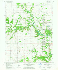
 1965 Humrick1967 Print · USGSVermilion County transitions from prairie to river bluffs in the mid-1960s as rail lines converge near the state line. Researchers can trace the Old Indian Treaty Boundary and locate community sites like McKendree Ch or the Wingard Sch.2 unique versions available
 - 1965 Map of Scottland, 1967 Print
 1965 Scottland1967 Print · USGSThe Illinois-Indiana borderlands in the mid-1960s are defined here by a network of cross-state railways and quiet rural crossroads. Researchers can trace ancestral roots through numerous family and community sites like Old Hopewell Cemetery, Wesley Chapel, and Quaker.2 unique versions available
 - 1966 Map of Sandford, 1967 Print
 1966 Sandford1967 Print · USGSThe Illinois-Indiana borderlands come alive in the mid-1960s, showing a landscape defined by coal mining and cross-state rail lines. Genealogists and local historians can trace family locations near Sandford and Libertyville or find old burial sites like Vermilion Cem and Gymon Cem.3 unique versions available
 - 1966 Map of Saint Bernice, 1967 Print
 1966 Saint Bernice1967 Print · USGSThe Illinois-Indiana borderlands are captured here in the mid-1960s, showing a landscape defined by the Milwaukee Road rail line and fertile creek bottoms. Genealogists can trace family footprints through numerous rural landmarks like Old Scott Cem, St Aloysius Ch, and the settlement of Saint Bernice.3 unique versions available
 - 1966 Map of Chrisman, 1967 Print
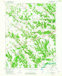
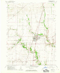 1966 Chrisman1967 Print · USGSEastern Illinois prairie life in the mid-sixties centered on the busy rail crossroads of Chrisman. Researchers can trace old family lines through Gaines Cem and Hoult Cem, or locate long-standing rural junctions at Cherry Point and Edgar.
 - 1966 Map of Georgetown, 1967 Print
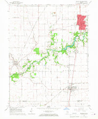 1966 Georgetown1967 Print · USGSThe Illinois and Indiana borderlands thrived in the mid-sixties as a hub of rail transit and agricultural commerce. Researchers can trace historic family burial sites like Sandusky Cem and Crown Hill Cem or locate community centers like Vermilion Grove and Bunsenville.2 unique versions available
 - 1966 Map of Paris South, 1967 Print
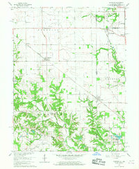
 1966 Paris South1967 Print · USGSThe city of Paris and its surrounding townships are shown in the mid-1960s at a time of robust rail activity and established rural neighborhoods. Genealogists can trace family landmarks like the Redmon Cem and Simms Cem, or locate historic school sites such as Mayo Sch and Crestwood Sch.2 unique versions available
 - 1966 Map of Paris North, 1967 Print
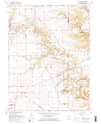
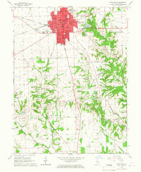
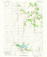 1966 Paris North1967 Print · USGSNorthern Edgar County in the mid-sixties reveals a landscape of productive prairie farms and the steady expansion of Paris. Researchers can locate family sites near Sixteen Cem, the crossroads at Horace, or along the New York Central rail line.3 unique versions available
End of results
Showing maps 1-11 of 11
Top cities of Edgar County
- Paris historical maps
- Chrisman historical maps
- Kansas historical maps
- Elbridge historical maps
- Grandview historical maps
- Edgar historical maps
See more
Frequently asked questions
- What are the different types of historical maps available for Edgar County?
- What is the oldest map of Edgar County?
- Where can I purchase historical maps of Edgar County for my home or office?
- Where can I download high-res historical maps of Edgar County?
- Are there historical topographic maps available for Edgar County?
- Is there historical aerial imagery available for Edgar County?
- Where are historical maps of Edgar County sourced from?