1970s Maps of Fulton County, Illinois
Explore 10 historic maps of Fulton County from the 1970s. These maps offer a rare glimpse into what life looked like during the 1970s — showing old roads, neighborhoods, homes, and landmarks that have changed or disappeared over time.
Whether you're researching your family's past, planning a metal detecting trip, or studying how Fulton County's landscape evolved across the 1970s, these high-resolution maps are a powerful tool for exploring the history of this region.
- Focus on a specific era: All maps on this page are from the 1970s, giving you a focused view of this time period.
- See what’s changed: Compare century-old streets, trails, and buildings to today's modern landscape using overlays and satellite layers.
- Research with precision: Use these maps for genealogy, historical research, land use analysis, or educational projects.
- View, download, or print: Maps are fully viewable online in high resolution, and can be downloaded or printed for your own records.
Start exploring Fulton County's history through authentic maps from the 1970s. This is your window into the past.
Fulton County, IL maps
(10)- 1971 Map of Glasford, 1974 Print
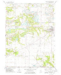
 1971 Glasford1974 Print · USGSThe Illinois River valley in the early 1970s reveals a landscape defined by heavy industry and small-town roots. Researchers can trace local genealogy through Lancaster Cem and Union Cem, or explore the industrial riverfront near Kingston Mines.
 - 1974 Map of Farmington West, 1978 Print
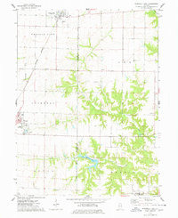
 1974 Farmington West1978 Print · USGSFulton County industrial and rural life are captured here in the mid-seventies, showing the expansion of heavy coal mining across the prairie. Researchers can trace family history through sites like Providence Chapel, Chapin Pleasant Hill Cem, and the village of Uniontown.
 - 1974 Map of Bushnell East, 1978 Print
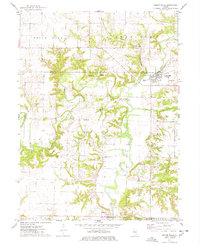
 1974 Bushnell East1978 Print · USGSPrairie City and Bushnell sit at a vital rail crossroads during the mid-seventies, where agriculture meets early recreational development. Trace local lineage and industry through Mound Cem, the First Baptist Ch, and a large Strip Mine.
 - 1974 Map of London Mills, 1978 Print
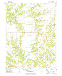
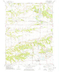
 1974 London Mills1978 Print · USGSThe Spoon River valley in the mid-1970s shows a landscape of small river towns and active coal mining. Genealogists and historians can trace the paths between London Mills and Ellisville, identifying family landmarks like Heartley Cem and the Indian Ford Bridge.
 - 1974 Map of Blyton, 1978 Print
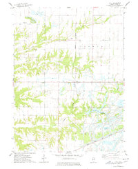
 1974 Blyton1978 Print · USGSIn the mid-1970s, this portion of Fulton County remained a landscape of winding river valleys and quiet rural townships. Local historians can trace the paths of old crossings like Buckeye Bridge and locate family landmarks such as Rigdon Cem and Sinnett Chapel Cems.2 unique versions available
 - 1974 Map of Fiatt, 1978 Print
 1974 Fiatt1978 Print · USGSFulton County land use comes into focus during the mid-seventies as coal extraction and recreation begin to reshape the prairie. Trace family roots at Fiatt Cem or Zion Ch while following the industrial footprints of the Burlington Northern and Strip Mined Areas.
 - 1974 Map of Avon, 1978 Print
 1974 Avon1978 Print · USGSThe rail-corridor communities of west-central Illinois are documented here in the mid-1970s as they transition into the late twentieth century. Researchers can locate numerous family-named burial grounds like Babbitt Cem or trace the rural footprint of Saunders Hospital and the Long Landing Strip.
 - 1974 Map of Canton, 1978 Print
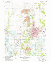 1974 Canton1978 Print · USGSCanton and its surrounding coalfields are captured here in the mid-seventies, showing a landscape defined by industry and community. Genealogists and local historians can trace family locations through Greenwood Cemetery, Shields Chapel, and the grounds of Spoon River Jr College.
 - 1974 Map of Fairview, 1978 Print
 1974 Fairview1978 Print · USGSMid-1970s Fulton and Knox Counties reveal a landscape shaped by both the Chicago and North Western rail line and large-scale coal extraction. Genealogists can locate several family cemeteries, including Markley Cem and Beer Cem, alongside local landmarks like Coal Creek Ch.
 - 1975 Map of Chandlerville NW, 1976 Print
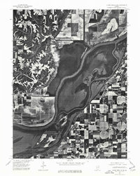 1975 Chandlerville NW1976 Print · USGSThe Illinois riverfront near Mason County comes to life in this mid-seventies aerial survey. Researchers can trace the layout of Bath and study the detailed agricultural patterns and backwaters surrounding the Illinois River.
End of results
Showing maps 1-10 of 10
Top cities of Fulton County
- Canton historical maps
- Farmington historical maps
- Lewistown historical maps
- Cuba historical maps
- Astoria historical maps
- Avon historical maps
See more
Frequently asked questions
- What are the different types of historical maps available for Fulton County?
- What is the oldest map of Fulton County?
- Where can I purchase historical maps of Fulton County for my home or office?
- Where can I download high-res historical maps of Fulton County?
- Are there historical topographic maps available for Fulton County?
- Is there historical aerial imagery available for Fulton County?
- Where are historical maps of Fulton County sourced from?