1990s Maps of Morris, Illinois
Explore 3 historic maps of Morris from the 1990s. These maps offer a rare glimpse into what life looked like during the 1990s — showing old roads, neighborhoods, homes, and landmarks that have changed or disappeared over time.
Whether you're researching your family's past, planning a metal detecting trip, or studying how Morris's landscape evolved across the 1990s, these high-resolution maps are a powerful tool for exploring the history of this region.
- Focus on a specific era: All maps on this page are from the 1990s, giving you a focused view of this time period.
- See what’s changed: Compare century-old streets, trails, and buildings to today's modern landscape using overlays and satellite layers.
- Research with precision: Use these maps for genealogy, historical research, land use analysis, or educational projects.
- View, download, or print: Maps are fully viewable online in high resolution, and can be downloaded or printed for your own records.
Start exploring Morris's history through authentic maps from the 1990s. This is your window into the past.
Morris, IL maps
(3)- 1991 Map of Ottawa
 1991 Ottawa1991 Print · USGSNorth-central Illinois in the early nineties remains a vital corridor of river commerce and heavy rail. Genealogists and historians can trace the legacy of industrial mining near Morris or explore the river-bluff geography of Starved Rock State Park and Buffalo Rock.
 - 1993 Map of Lisbon, 1994 Print
 1993 Lisbon1994 Print · USGSLisbon and Morris appear at the start of the nineties, where the quiet prairie of Kendall and Grundy counties meets the historic canal corridor. Researchers can trace family sites at Saratoga Cem and Saratoga Sch Cem or locate the Nelson Landing Strip and John Moore Park.
 - 1993 Map of Morris, 1994 Print
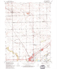
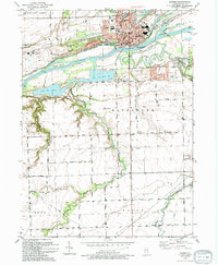 1993 Morris1994 Print · USGSThe Illinois River corridor near Morris thrives as a hub of canal history and rail transport in the early nineties. Genealogists and local historians can locate Evergreen Cem, trace the CSX RR line, and find vanished rural landmarks like Pavilionville.
End of results
Showing maps 1-3 of 3
Top cities near Morris
- Joliet historical maps
- Plainfield historical maps
- Yorkville historical maps
- Channahon historical maps
- Shorewood historical maps
- Minooka historical maps
See more
Frequently asked questions
- What are the different types of historical maps available for Morris?
- What is the oldest map of Morris?
- Where can I purchase historical maps of Morris for my home or office?
- Where can I download high-res historical maps of Morris?
- Are there historical topographic maps available for Morris?
- Is there historical aerial imagery available for Morris?
- Where are historical maps of Morris sourced from?