1900s (20th Century) Maps of Hamilton County, Illinois
Explore 39 historic maps of Hamilton County from the 1900s (20th Century). These maps offer a rare glimpse into what life looked like during the 1900s — showing old roads, neighborhoods, homes, and landmarks that have changed or disappeared over time.
Whether you're researching your family's past, planning a metal detecting trip, or studying how Hamilton County's landscape evolved across the 1900s, these high-resolution maps are a powerful tool for exploring the history of this region.
- Focus on a specific era: All maps on this page are from the 1900s, giving you a focused view of this time period.
- See what’s changed: Compare century-old streets, trails, and buildings to today's modern landscape using overlays and satellite layers.
- Research with precision: Use these maps for genealogy, historical research, land use analysis, or educational projects.
- View, download, or print: Maps are fully viewable online in high resolution, and can be downloaded or printed for your own records.
Start exploring Hamilton County's history through authentic maps from the 1900s. This is your window into the past.
Hamilton County, IL maps
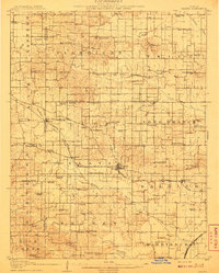
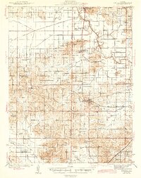
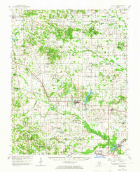
(39)- 1905 Map of Eldorado, 1954 Print
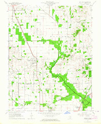
 1905 Eldorado1954 Print · USGSSouthern Illinois rail hubs and prairie settlements thrive at the turn of the century. Genealogists can trace family roots through old stops like Texas City, Gossett, and Francis Mills, or locate early industrial sites like the Dering Mine.
 - 1906 Map of Eldorado
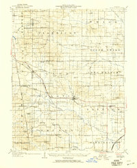
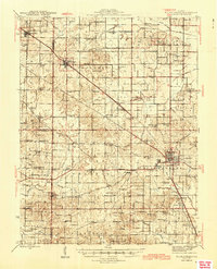
 1906 Eldorado1906 Print · USGSSouthern Illinois at the turn of the century is a bustling web of competing rail lines and river-bottom settlements. Genealogists and rail historians can trace the early footprints of Eldorado, Ridgway, and the milling history at Francis Mills.2 unique versions available
 - 1908 Map of Galatia
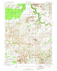
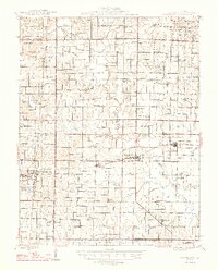
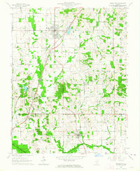
 1908 Galatia1908 Print · USGSSouthern Illinois at the dawn of the twentieth century was a landscape of thriving rural communities and rail-side towns. Genealogists can trace family roots through numerous local landmarks like Possum Flat School, Tate Township Hall, and Mount Pleasant Church.2 unique versions available
 - 1938 Map of Galatia, 1959 Print
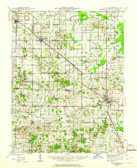
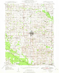
 1938 Galatia1959 Print · USGSThe Southern Illinois interior near the Saline River comes to life in this survey from the late thirties. Genealogists and historians can trace family roots through numerous local landmarks like Thistle Ridge School, Tate Chapel, and Akin.
 - 1941 Map of Enfield, 1968 Print
 1941 Enfield1968 Print · USGSWhite and Hamilton counties in the early 1940s were defined by a vast network of rural school districts and rail-connected hamlets. Genealogists can trace family roots through numerous local landmarks, from the Burnt Prairie P O to the McIntosh Cem and Wildcat Sch.
 - 1942 Map of McLeansboro, 1961 Print
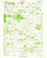
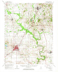
 1942 McLeansboro1961 Print · USGSHamilton County in the early 1940s was a landscape of tightly-knit farming communities and small rail stops. Genealogists can trace family roots through a remarkable number of local landmarks like Piopolis, Seminary Sch, and Union Hill Cem.2 unique versions available
 - 1944 Map of Enfield
 1944 Enfield1944 Print · USGSSoutheastern Illinois in the early 1940s is defined here by a dense grid of rural schools and the intersection of major rail lines. Researchers can trace ancestral locations through the dozens of named institutions like McIntosh Settlement, Asbury Ch, and Trousdale Sch.2 unique versions available
 - 1945 Map of McLeansboro
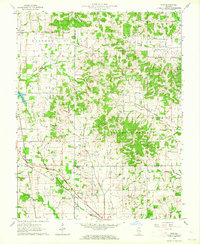
 1945 McLeansboro1945 Print · USGSIn the mid-1940s, this portion of Southern Illinois was a landscape of steam-era rail junctions and tight-knit rural school districts. Genealogists can trace family roots through scores of rural landmarks, from Knight Prairie and Piopolis to the Sulphur Springs Sch.2 unique versions available
 - 1947 Map of Wayne City
 1947 Wayne City1947 Print · USGSSouthern Illinois in the mid-1940s is captured here at a time when small rural schools and country churches still defined the local geography. Researchers can trace the rail-centered growth of Wayne City and Bluford or locate family sites like Garrison Temple, Thomason Cem, and Berry Sch.3 unique versions available
 - 1948 Map of Fairfield
 1948 Fairfield1948 Print · USGSWayne County is captured in the late 1940s as a thriving network of small rail towns and rural school districts. Genealogists and historians can trace family locations near Pure Gold Sch, the Crews Cem, or the rail junction at Fairfield.2 unique versions available
 - 1949 Map of Paducah
 1949 Paducah1949 Print · USGSThe confluence of the Ohio, Mississippi, Tennessee, and Cumberland rivers at the close of the 1940s reveals a region bound by water and rail. Researchers can trace historic river landings, timberlands in the Shawnee National Forest, and the coal-mining infrastructure around West Frankfort and Herrin.2 unique versions available
 - 1950 Map of Paducah
 1950 Paducah1950 Print · USGSThe confluence of the great midwestern rivers defines this mid-century landscape at the intersection of Illinois, Kentucky, and Missouri. Genealogists and historians can trace the rail-and-river economy through the hubs of Paducah, Cairo, and Metropolis or locate family roots near the Wildcat Hills.
 - 1954 Map of Paducah
 1954 Paducah1954 Print · USGSSouthern Illinois and Western Kentucky intersect at the great river confluences during this mid-century era of rail and river industry. Genealogists and historians can trace family roots and commerce through river towns like Cairo, Metropolis, and Golconda, or along the tracks of the Illinois Central Railroad.2 unique versions available
 - 1958 Map of Belleville, 1973 Print
 1958 Belleville1973 Print · USGSSouthern Illinois during the mid-twentieth century reveals a landscape of industrial growth and massive new reservoirs. Genealogists and historians can trace the paths of the Illinois Central RR through towns like Centralia or locate landmarks such as Emerald Mound and the Looking Glass Prairie.3 unique versions available
 - 1961 Map of Paducah
 1961 Paducah1961 Print · USGSThe Lower Ohio Valley at mid-century is a landscape defined by its great rivers and newly formed reservoirs. Researchers can trace the riverfronts of Paducah and Metropolis, or locate smaller settlements like Old Shawneetown and Cave in Rock along the banks.2 unique versions available
 - 1962 Map of Belleville
 1962 Belleville1962 Print · USGSSouthern Illinois in the late fifties reveals a landscape of industrial growth and ancient landmarks before the full expansion of the interstate system. Genealogists can trace family names and rural post offices near Centralia, Salem, and the historic Monks Mound.
 - 1963 Map of Broughton, 1964 Print
 1963 Broughton1964 Print · USGSSouthern Illinois during the early sixties is captured here as a landscape of rail-dependent villages and rural parishes. Genealogists can locate family landmarks like Gholson Grove Ch, Broughton Sch, and Latham Cem along the Louisville and Nashville line.
 - 1963 Map of Norris City, 1964 Print
 1963 Norris City1964 Print · USGSSouthern Illinois during the early sixties is captured here at the rail junction of Norris City and the rural prairies of White County. Researchers can trace ancestral sites like the Odd Fellows Cem and vanished landmarks such as Gossett Station.2 unique versions available
 - 1963 Map of Walpole, 1964 Print
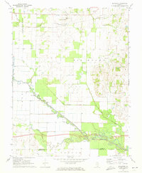
 1963 Walpole1964 Print · USGSSouthern Illinois prairie life and the 1960s petroleum boom meet at the Hamilton and Saline County line. Researchers can locate early rural hubs like Walpole, trace family lineage at Rhine Cem Ch, and see the extent of the active Oil Field.2 unique versions available
 - 1963 Map of Akin, 1964 Print
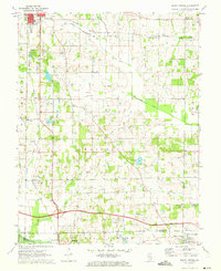
 1963 Akin1964 Print · USGSHamilton County is captured in the early sixties as a rural landscape of church-centered hamlets and coal-belt rail lines. Genealogists can locate Akin, West Rural Hill, and numerous family burial grounds like Brady Cem and Good Hope Cem.
 - 1963 Map of Galatia, 1966 Print
 1963 Galatia1966 Print · USGSSouthern Illinois in the early sixties was a landscape defined by coal, oil, and the rails of the Illinois Central. Genealogists can trace family roots through numerous remote burial grounds like Old Ruff Cem and Masonic Cem, or locate landmarks such as Tate Chapel and Harco.2 unique versions available
 - 1963 Map of Eldorado, 1966 Print
 1963 Eldorado1966 Print · USGSSouthern Illinois in the early sixties shows a landscape shaped by coal, oil, and the crossing of three major railroads. Genealogists can trace family names at Gholson Cem and Lantham Cem or locate the old Broughton Sch and Gossett Station.
 - 1964 Map of Paducah
 1964 Paducah1964 Print · USGSThe river-and-rail corridor of Southern Illinois and Western Kentucky is captured here during the height of the mid-century industrial era. Genealogists and researchers can trace local landmarks across several counties, from the rail yards of Paducah to the waters of Crab Orchard Lake and Kentucky Reservoir.2 unique versions available
 - 1971 Map of Boyleston, 1973 Print
 1971 Boyleston1973 Print · USGSSouthern Illinois farming and drainage systems are in full view here in the early 1970s. Genealogists and historians can trace family burial sites like Clark Cem, rural schools like Boyleston Sch, and the winding path of the Skillet Fork.
 - 1971 Map of Burnt Prairie, 1973 Print
 1971 Burnt Prairie1973 Print · USGSSoutheastern Illinois reveals a landscape of active petroleum extraction and family homesteads in the early seventies. Genealogists and historians can trace numerous rural burial grounds like Koontz Cem and Gifford Cem alongside the heavy rail presence of the Baltimore and Ohio RR.
Showing maps 1-25 of 39
Top cities of Hamilton County
- McLeansboro historical maps
- Dahlgren historical maps
- Broughton historical maps
- Belle Prairie City historical maps
Frequently asked questions
- What are the different types of historical maps available for Hamilton County?
- What is the oldest map of Hamilton County?
- Where can I purchase historical maps of Hamilton County for my home or office?
- Where can I download high-res historical maps of Hamilton County?
- Are there historical topographic maps available for Hamilton County?
- Is there historical aerial imagery available for Hamilton County?
- Where are historical maps of Hamilton County sourced from?