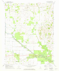
1971 Map of Boyleston
USGS Topo · Published 1973About this map
Boyleston and its surrounding countryside are defined by the complex water management of the Southern Illinois prairie, where the Southern railroad tracks run parallel to local creeks. The landscape is a mix of agricultural fields and structured drainage, most notably the Eagle Slough Drainage Ditch and the Drainage Ditch network that directs water toward the Skillet Fork. This 1970s survey captures the region just as modern infrastructure was expanding, indicated by a prominent highway section labeled Under Construction near the Lagoon. Local life and genealogy are anchored by rural institutions like Richland Ch, Full Gospel Ch, and the Ellis Mound Ch school site. Small family burial grounds, including Clark Cem and Hall Cem, sit amidst the high ground of Big Mound and the eastern Ridge, offering a precise record of established settlement patterns before the further consolidation of 20th-century farming.
Find a feature on this map
35 named features on this map. Tap any name to fly to it.
Don’t see what you’re looking for? This feature index may not catch every label — zoom into the map to look around manually.
Map Details
Editions of this 1971 Boyleston Map
This is the sole edition of this map. No revisions or reprints were ever made.
Other maps of this area

1941 · Enfield
USGS Topo · 1:62,500

1942 · McLeansboro
USGS Topo · 1:62,500

1944 · Enfield
USGS Topo · 1:62,500

1945 · McLeansboro
USGS Topo · 1:62,500

1947 · Wayne City
USGS Topo · 1:62,500

1948 · Fairfield
USGS Topo · 1:62,500

1958 · Belleville
USGS Topo · 1:250,000

1962 · Belleville
USGS Topo · 1:250,000
1970 · Geff
USGS Topo · 1:24,000
1971 · Burnt Prairie
USGS Topo · 1:24,000