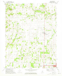
1970 Map of Geff
USGS Topo · Published 1973About this map
Geff (Jeffersonville) stands as a primary focal point in this 1970 landscape, where the rural grid of Wayne County is defined by a mix of agricultural plots and intensive industrial activity. The area is heavily marked by the Clay City Oil Field and the Johnsonville Oil Field, with numerous wells and pipelines cutting across the terrain of Indian Prairie and Lamard. The Baltimore and Ohio railroad provides the principal transportation artery, passing near the Fairfield Municipal Airport and the outskirts of Fairfield. Community life is anchored by a dense network of country churches and burial grounds, such as Pleasant Grove Ch, Martin Creek Ch, and Cambell Cem. This era shows a transition where traditional landmarks like the New Salem Ch exist alongside modern features such as a Drive-in Theater and the waters of In-Dan-Wayne Lake.
Find a feature on this map
36 named features on this map. Tap any name to fly to it.
Don’t see what you’re looking for? This feature index may not catch every label — zoom into the map to look around manually.
Map Details
Editions of this 1970 Geff Map
This is the sole edition of this map. No revisions or reprints were ever made.
Other maps of this area

1947 · Wayne City
USGS Topo · 1:62,500

1948 · Fairfield
USGS Topo · 1:62,500

1948 · Flora
USGS Topo · 1:62,500

1949 · Flora
USGS Topo · 1:62,500

1952 · Xenia
USGS Topo · 1:62,500

1958 · Belleville
USGS Topo · 1:250,000

1962 · Belleville
USGS Topo · 1:250,000
1968 · Johnsonville
USGS Topo · 1:24,000

1970 · Enterprise
USGS Topo · 1:24,000
1970 · Cisne
USGS Topo · 1:24,000