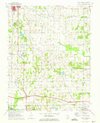
1971 Map of Burnt Prairie
USGS Topo · Published 1973About this map
The Barnhill Oil Field and Golden Gate Oil Field dominate this rural landscape in southeastern Illinois, reflecting the region's mid-century petroleum development. Numerous oil wells are scattered across the terrain, interspersed with a grid of family-named cemeteries such as Shaeffer Cem, Wright Cem, and Puckett Cem. The landscape is a mix of agricultural plots and managed waterways, including the Skillet Fork Drainage Ditch and the Pond Creek Drainage Ditch, which redirect the natural flow of the southern flatlands.
Find a feature on this map
41 named features on this map. Tap any name to fly to it.
Don’t see what you’re looking for? This feature index may not catch every label — zoom into the map to look around manually.
Map Details
Editions of this 1971 Burnt Prairie Map
This is the sole edition of this map. No revisions or reprints were ever made.
Other maps of this area

1940 · Carmi
USGS Topo · 1:62,500

1941 · Enfield
USGS Topo · 1:62,500

1943 · Carmi
USGS Topo · 1:62,500

1943 · Albion
USGS Topo · 1:62,500

1944 · Enfield
USGS Topo · 1:62,500

1946 · Albion
USGS Topo · 1:62,500

1948 · Fairfield
USGS Topo · 1:62,500

1958 · Belleville
USGS Topo · 1:250,000

1962 · Belleville
USGS Topo · 1:250,000
1970 · Geff
USGS Topo · 1:24,000