1900s (20th Century) Maps of Iroquois County, Illinois
Explore 82 historic maps of Iroquois County from the 1900s (20th Century). These maps offer a rare glimpse into what life looked like during the 1900s — showing old roads, neighborhoods, homes, and landmarks that have changed or disappeared over time.
Whether you're researching your family's past, planning a metal detecting trip, or studying how Iroquois County's landscape evolved across the 1900s, these high-resolution maps are a powerful tool for exploring the history of this region.
- Focus on a specific era: All maps on this page are from the 1900s, giving you a focused view of this time period.
- See what’s changed: Compare century-old streets, trails, and buildings to today's modern landscape using overlays and satellite layers.
- Research with precision: Use these maps for genealogy, historical research, land use analysis, or educational projects.
- View, download, or print: Maps are fully viewable online in high resolution, and can be downloaded or printed for your own records.
Start exploring Iroquois County's history through authentic maps from the 1900s. This is your window into the past.
Iroquois County, IL maps
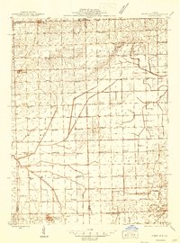
(82)- 1922 Map of Momence, 1958 Print
 1922 Momence1958 Print · USGSThe Kankakee River valley in the early twenties is a landscape of river islands and busy rail junctions. Genealogists and historians can locate dozens of country schools like Frogtown School and Searls School or trace the Illinois-Indiana border at Illinoi.
 - 1922 Map of Kankakee, 1959 Print
 1922 Kankakee1959 Print · USGSThe Kankakee valley thrived in the early 1920s as a major crossroads of electric interurbans and transcontinental railroads. Researchers can trace the footprints of numerous rural schoolhouses, the East Illinois Hospital grounds, and historic routes like the Egyptian Trail.2 unique versions available
 - 1923 Map of Herscher, 1959 Print
 1923 Herscher1959 Print · USGSKankakee and Will Counties in the early twenties show a landscape defined by busy rail junctions and a dense network of rural school districts. Genealogists and researchers can locate family-named landmarks and infrastructure like the Lehigh Stone Co Quarry, Appel Siding, and Essex Center School.2 unique versions available
 - 1924 Map of Momence
 1924 Momence1924 Print · USGSEastern Illinois and the Indiana borderlands are captured here during the 1920s, showing a landscape defined by the Kankakee River and a web of rail lines. Researchers can trace dozens of legacy district schools like Frogtown School and locate family landmarks in Momence, St Anne, and Grant Park.2 unique versions available
 - 1924 Map of Kankakee
 1924 Kankakee1924 Print · USGSThe Kankakee riverfront and its surrounding townships thrived in the early 1920s as a major hub for both industry and electric transit. Researchers can trace dozens of rural schoolhouses and vanished rail stops, from Altdorf School to the Illinois Electric Interurban station at Tucker.2 unique versions available
 - 1924 Map of Paxton, 1953 Print
 1924 Paxton1953 Print · USGSEast-central Illinois comes into focus during the mid-twenties as the rail lines and early airfields transformed the prairie. Researchers can locate dozens of family-named schools like Lily Dell School and trace the original layout of Chanute Flying Field.
 - 1925 Map of Herscher
 1925 Herscher1925 Print · USGSKankakee and Grundy counties appear here during the 1920s as a thriving corridor of railroads and rural schools. Genealogists can trace family names through landmarks like Yates School, Clarke City, and the Lehigh Stone Co Quarry.2 unique versions available
 - 1927 Map of Paxton
 1927 Paxton1927 Print · USGSIllinois prairie life in the mid-twenties is captured here through a dense network of township schools and the rise of military aviation. Genealogists and local historians can trace family locations near Chanute Flying Field or find long-standing rural landmarks like Lily Dell School and Glen Cemetery.2 unique versions available
 - 1933 Map of Hoopeston
 1933 Hoopeston1933 Print · USGSVermilion County and the Illinois-Indiana borderlands are captured here in the early 1930s as a thriving rail and agricultural corridor. Genealogists can locate dozens of rural schools like White Sch and family-linked landmarks such as Ross Cem or Manns Chapel.
 - 1935 Map of Watseka
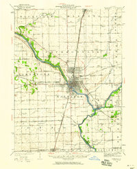
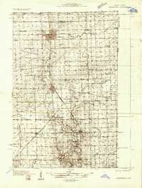
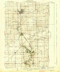
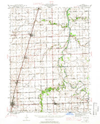
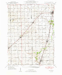
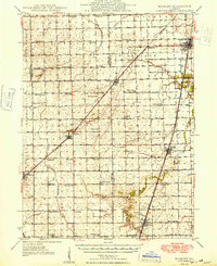
 1935 Watseka1935 Print · USGSIroquois County in the mid-1930s is a landscape of thriving rail-side villages and rural school districts connected by a dense rail network. Researchers can trace family history through dozens of landmarks like Independence Sch, Mt Taber Ch, and St Joseph Cem.
 - 1936 Map of Potomac
 1936 Potomac1936 Print · USGSThe rural prairie of Vermilion County thrives as a rail-and-river economy during the mid-1930s. Researchers can trace dozens of country schools and family-named landmarks like St Lawrence Ch, Rankin Union Cem, and river crossings at Bass Ford.3 unique versions available
 - 1938 Map of Milford
 1938 Milford1938 Print · USGSIroquois County at the end of the Depression era is a landscape of thriving rail towns and numerous one-room schoolhouses. Researchers can locate nearly thirty distinct rural schools like White College Sch and Fidelity Sch, along with family burial grounds such as Belmont Cem.
 - 1938 Map of Hoopeston
 1938 Hoopeston1938 Print · USGSEastern Illinois at the height of the rail era shows a landscape defined by busy junctions and tightly knit rural communities. Genealogists and historians can trace family roots through dozens of local landmarks like Squankum Sch, Rose Cem, and Pleasant View Ch.3 unique versions available
 - 1939 Map of Watseka
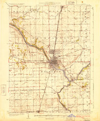
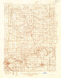
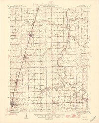
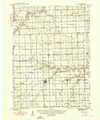
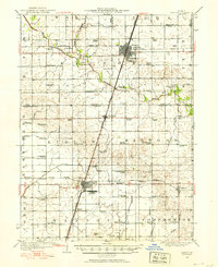
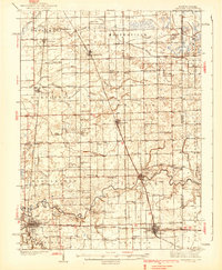 1939 Watseka1939 Print · USGSIroquois County and the Illinois-Indiana borderlands are captured here during the mid-1930s as a thriving rail and agricultural corridor. Researchers can trace dozens of country schools like Weygandt Sch, small communities like Beaverville, and the grounds of the County Farm.2 unique versions available
 - 1939 Map of Cissna Park, 1940 Print
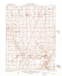
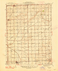
 1939 Cissna Park1940 Print · USGSIroquois County at the end of the 1930s reveals a vast network of one-room schools and prairie rail stops. Genealogists can trace family footprints across dozens of rural landmarks, from Possum Trot Sch and Prairie Queen Sch to the quiet grounds of ASH GROVE CEM.
 - 1944 Map of Milford
 1944 Milford1944 Print · USGSIroquois County at the close of the second World War is a landscape defined by rail junctions and rural schoolhouses. Genealogists can trace family roots through numerous sites like Sugar Creek Chapel, Belmont Cem, and early schools including White College Sch.2 unique versions available
 - 1944 Map of Piper City
 1944 Piper City1944 Print · USGSEast-central Illinois was a landscape of thriving rural school districts and critical rail junctions during the 1940s. Genealogists can locate dozens of family-named landmarks and schools such as Graham Sch and Taylor Sch alongside the Illinois Central tracks.2 unique versions available
 - 1944 Map of Gilman, 1966 Print
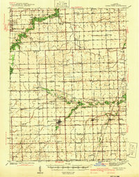
 1944 Gilman1966 Print · USGSIroquois County at the end of the Second World War reveals a dense network of prairie schoolhouses and rail towns. Genealogists can trace family names through Clark Cem and dozens of country schools like Swival Sch or Ross Farm Sch.2 unique versions available
 - 1946 Map of Gilman
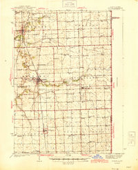
 1946 Gilman1946 Print · USGSIroquois County at the close of World War II is a landscape defined by the iron rails and the prairie. Researchers can trace rural school districts like Old Burg Sch and locate ancestral burial grounds such as Bardon Cem and Pierce Cem.2 unique versions available
 - 1947 Map of Piper City
 1947 Piper City1947 Print · USGSFord County and the surrounding prairie are captured here in the mid-1940s, showing a landscape defined by rail transport and township schools. Genealogists can locate family landmarks like Milks Grove Ch, the Town Hall, and dozens of named country schools.
 - 1948 Map of Buckley
 1948 Buckley1948 Print · USGSThe Illinois prairie of the late 1940s reveals a rural landscape still revolving around the village schoolhouse and the Illinois Central rail line. Trace family roots and vanished landmarks across Piper City, Thawville, and dozens of rural schools like Shute Sch or Zahn Sch.
 - 1949 Map of Cissna Park
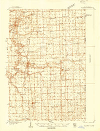
 1949 Cissna Park1949 Print · USGSIroquois County's agricultural heartland is documented here in the years following World War II, showing a landscape defined by small farms and rail-stop villages. Researchers can locate dozens of localized landmarks, from Amity Cem to uniquely named rural schools like Possum Trot Sch and Pond Lily Sch.3 unique versions available
 - 1949 Map of Buckley
 1949 Buckley1949 Print · USGSEast-central Illinois farm country thrived alongside the Illinois Central railroad just after the war, when small towns and family farms defined the prairie. Researchers can locate dozens of country schoolhouses like Willow Grove Sch and Larkin Sch, or trace the path of the North Fork Vermilion River near Thawville.2 unique versions available
 - 1949 Map of Paxton
 1949 Paxton1949 Print · USGSCentral Illinois thrived as a rail and military corridor in the mid-1920s, anchored by the crossroads of two major rail lines. Researchers can trace the early footprint of Chanute Flying Field and locate dozens of vanished rural schoolhouses like Trickel Grove School and Farmersville School.
 - 1953 Map of Chicago, 1964 Print
 1953 Chicago1964 Print · USGSThe southern Lake Michigan shoreline was rapidly modernizing in the mid-fifties, balancing heavy industry with its famous academic centers. Researchers can trace the footprints of Notre Dame University or locate vanished sites like the Kingsbury Ordnance Plant and Meigs Field.5 unique versions available
Showing maps 1-25 of 82
Top cities of Iroquois County
- Watseka historical maps
- Gilman historical maps
- Onarga historical maps
- Milford historical maps
- Clifton historical maps
- Sheldon historical maps
See more
Frequently asked questions
- What are the different types of historical maps available for Iroquois County?
- What is the oldest map of Iroquois County?
- Where can I purchase historical maps of Iroquois County for my home or office?
- Where can I download high-res historical maps of Iroquois County?
- Are there historical topographic maps available for Iroquois County?
- Is there historical aerial imagery available for Iroquois County?
- Where are historical maps of Iroquois County sourced from?