1930s Maps of Iroquois County, Illinois
Explore 7 historic maps of Iroquois County from the 1930s. These maps offer a rare glimpse into what life looked like during the 1930s — showing old roads, neighborhoods, homes, and landmarks that have changed or disappeared over time.
Whether you're researching your family's past, planning a metal detecting trip, or studying how Iroquois County's landscape evolved across the 1930s, these high-resolution maps are a powerful tool for exploring the history of this region.
- Focus on a specific era: All maps on this page are from the 1930s, giving you a focused view of this time period.
- See what’s changed: Compare century-old streets, trails, and buildings to today's modern landscape using overlays and satellite layers.
- Research with precision: Use these maps for genealogy, historical research, land use analysis, or educational projects.
- View, download, or print: Maps are fully viewable online in high resolution, and can be downloaded or printed for your own records.
Start exploring Iroquois County's history through authentic maps from the 1930s. This is your window into the past.
Iroquois County, IL maps
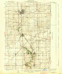
(7)- 1933 Map of Hoopeston
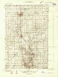 1933 Hoopeston1933 Print · USGSVermilion County and the Illinois-Indiana borderlands are captured here in the early 1930s as a thriving rail and agricultural corridor. Genealogists can locate dozens of rural schools like White Sch and family-linked landmarks such as Ross Cem or Manns Chapel.
 - 1935 Map of Watseka
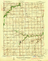
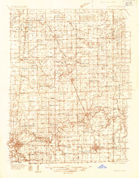 1935 Watseka1935 Print · USGSIroquois County in the mid-1930s is a landscape of thriving rail-side villages and rural school districts connected by a dense rail network. Researchers can trace family history through dozens of landmarks like Independence Sch, Mt Taber Ch, and St Joseph Cem.
 - 1936 Map of Potomac
 1936 Potomac1936 Print · USGSThe rural prairie of Vermilion County thrives as a rail-and-river economy during the mid-1930s. Researchers can trace dozens of country schools and family-named landmarks like St Lawrence Ch, Rankin Union Cem, and river crossings at Bass Ford.3 unique versions available
 - 1938 Map of Milford
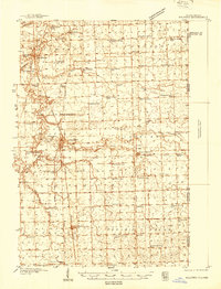 1938 Milford1938 Print · USGSIroquois County at the end of the Depression era is a landscape of thriving rail towns and numerous one-room schoolhouses. Researchers can locate nearly thirty distinct rural schools like White College Sch and Fidelity Sch, along with family burial grounds such as Belmont Cem.
 - 1938 Map of Hoopeston
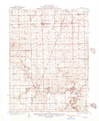
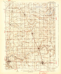
 1938 Hoopeston1938 Print · USGSEastern Illinois at the height of the rail era shows a landscape defined by busy junctions and tightly knit rural communities. Genealogists and historians can trace family roots through dozens of local landmarks like Squankum Sch, Rose Cem, and Pleasant View Ch.3 unique versions available
 - 1939 Map of Watseka
 1939 Watseka1939 Print · USGSIroquois County and the Illinois-Indiana borderlands are captured here during the mid-1930s as a thriving rail and agricultural corridor. Researchers can trace dozens of country schools like Weygandt Sch, small communities like Beaverville, and the grounds of the County Farm.2 unique versions available
 - 1939 Map of Cissna Park, 1940 Print
 1939 Cissna Park1940 Print · USGSIroquois County at the end of the 1930s reveals a vast network of one-room schools and prairie rail stops. Genealogists can trace family footprints across dozens of rural landmarks, from Possum Trot Sch and Prairie Queen Sch to the quiet grounds of ASH GROVE CEM.
End of results
Showing maps 1-7 of 7
Top cities of Iroquois County
- Watseka historical maps
- Gilman historical maps
- Onarga historical maps
- Milford historical maps
- Clifton historical maps
- Sheldon historical maps
See more
Frequently asked questions
- What are the different types of historical maps available for Iroquois County?
- What is the oldest map of Iroquois County?
- Where can I purchase historical maps of Iroquois County for my home or office?
- Where can I download high-res historical maps of Iroquois County?
- Are there historical topographic maps available for Iroquois County?
- Is there historical aerial imagery available for Iroquois County?
- Where are historical maps of Iroquois County sourced from?