1970s Maps of Kankakee County, Illinois
Explore 4 historic maps of Kankakee County from the 1970s. These maps offer a rare glimpse into what life looked like during the 1970s — showing old roads, neighborhoods, homes, and landmarks that have changed or disappeared over time.
Whether you're researching your family's past, planning a metal detecting trip, or studying how Kankakee County's landscape evolved across the 1970s, these high-resolution maps are a powerful tool for exploring the history of this region.
- Focus on a specific era: All maps on this page are from the 1970s, giving you a focused view of this time period.
- See what’s changed: Compare century-old streets, trails, and buildings to today's modern landscape using overlays and satellite layers.
- Research with precision: Use these maps for genealogy, historical research, land use analysis, or educational projects.
- View, download, or print: Maps are fully viewable online in high resolution, and can be downloaded or printed for your own records.
Start exploring Kankakee County's history through authentic maps from the 1970s. This is your window into the past.
Kankakee County, IL maps
(4)- 1973 Map of Herscher, 1975 Print
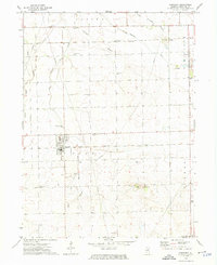 1973 Herscher1975 Print · USGSHerscher and the surrounding prairie of Kankakee County are shown here in the mid-seventies, captured as a vital rail and quarrying hub. Researchers can locate numerous family-named burial grounds like Mt Hope Cem and Grand Prairie Cem or trace the early paths of the Illinois Central Gulf.2 unique versions available
 - 1973 Map of Bonfield, 1975 Print
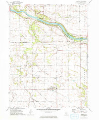 1973 Bonfield1975 Print · USGSKankakee County agriculture and river life are captured here in the early 1970s. Genealogists can locate family sites at Wesley Cem and Shreffler Cem or trace the early footprint of Bonfield and Frielings.
 - 1973 Map of Essex, 1975 Print
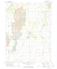 1973 Essex1975 Print · USGSIn the early 1970s, the landscape around the Grundy and Kankakee county line was shaped by heavy industry and rail. Genealogists and historians can trace the local cemetery sites and industrial hubs like Strip Mine, Clarke City, and Custer Park.3 unique versions available
 - 1973 Map of Buckingham, 1975 Print
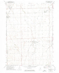 1973 Buckingham1975 Print · USGSThe Illinois prairie near the Kankakee county line is captured in the early 1970s, showcasing a rural landscape structured by rail and water. Researchers can trace the paths of the Norfolk and Western and Illinois Central Gulf through Buckingham and Union Hill.
End of results
Showing maps 1-4 of 4
Top cities of Kankakee County
- Kankakee historical maps
- Bourbonnais historical maps
- Bradley historical maps
- Manteno historical maps
- Momence historical maps
- Grant Park historical maps
See more
Frequently asked questions
- What are the different types of historical maps available for Kankakee County?
- What is the oldest map of Kankakee County?
- Where can I purchase historical maps of Kankakee County for my home or office?
- Where can I download high-res historical maps of Kankakee County?
- Are there historical topographic maps available for Kankakee County?
- Is there historical aerial imagery available for Kankakee County?
- Where are historical maps of Kankakee County sourced from?