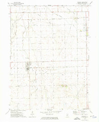
1973 Map of Herscher
USGS Topo · Published 1975About this map
Herscher serves as the primary hub of this 1970s landscape, characterized by the intersection of the Illinois Central Gulf and Penn Central railroads. The area's agricultural and industrial character is evident in the transition from the Salina and Pilot townships to the eastern Limestone township, where numerous quarries and gravel pits mark the land. For genealogists, the map is remarkably dense with burial sites including Mt Hope Cem, SS Peter & Paul Cem, and Pilot Center Cem, alongside landmarks like Zion Ch and Trinity Cem. The terrain is drained by Horse Creek and its branches, leading toward Pilot Hill in the south, while several pipelines and a Compressor Station underscore the modern infrastructure supporting the surrounding small settlements like Goodrich and Lehigh.
Find a feature on this map
36 named features on this map. Tap any name to fly to it.
Don’t see what you’re looking for? This feature index may not catch every label — zoom into the map to look around manually.
Map Details
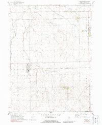
Editions of this 1973 Herscher Map
2 editions found
Other maps of this area

1922 · Kankakee
USGS Topo · 1:62,500

1923 · Herscher
USGS Topo · 1:62,500

1924 · Kankakee
USGS Topo · 1:62,500

1925 · Herscher
USGS Topo · 1:62,500

1944 · Piper City
USGS Topo · 1:48,000

1944 · Gilman
USGS Topo · 1:62,500

1946 · Gilman
USGS Topo · 1:62,500

1947 · Piper City
USGS Topo · 1:62,500

1953 · Chicago
USGS Topo · 1:250,000

1953 · Danville
USGS Topo · 1:250,000