Old Maps of Big Grove Township, Illinois for Academic Research
Study the evolution of Big Grove Township with 41 high-resolution historic maps. Whether you're teaching, researching, or modeling changes in land use, these maps provide essential visual documentation of urban, environmental, and geographic change.
- Analyze long-term change: Track patterns in development, transportation, and natural features.
- Ideal for environmental or urban studies: Support academic projects with primary historical map data.
- Use in the classroom or lab: Educators and researchers rely on these maps to bring historical context to life.
These maps are a powerful tool for teaching, research, and visualizing how Big Grove Township has changed over the decades.
Big Grove Township, IL maps
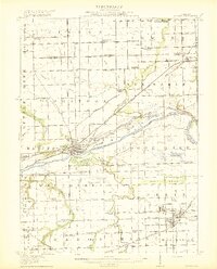
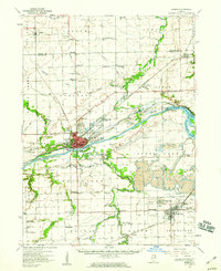
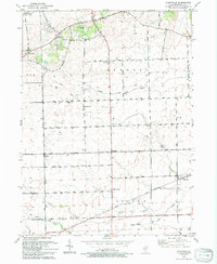
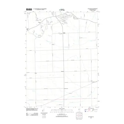
(41)- 1892 Map of Morris
 1892 Morris1892 Print · USGSGrundy County thrives as a transportation nexus in the 1890s, where the legendary canal system meets a growing web of iron rails. Trace early industrial footprints in Coal City or follow the path of the Illinois and Michigan Canal through Morris.3 unique versions available
 - 1892 Map of Marseilles
 1892 Marseilles1892 Print · USGSLaSalle County at the close of the nineteenth century showcases a bustling corridor of river commerce and rail expansion. Trace the historic path of the Illinois and Michigan Canal through Marseilles or locate early settlements like Norway and Stavanger.3 unique versions available
 - 1916 Map of Marseilles
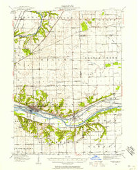
 1916 Marseilles1916 Print · USGSThe Illinois River valley in the early twentieth century shows a busy network of canals, electric railways, and rural schools. Trace the early layout of Marseilles, the Michigan Canal, and dozens of local landmarks like Norway and the Fox River Academy.4 unique versions available
 - 1918 Map of Morris
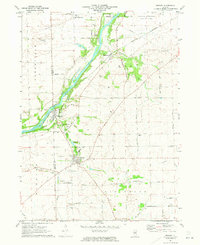
 1918 Morris1918 Print · USGSGrundy County at the end of the Great War is a landscape defined by the Illinois River and a bustling coal industry. Researchers can trace historic school districts like Jugtown School, the path of the Michigan and Illinois Canal, and early mining settlements such as Carbon Hill and Eileen.3 unique versions available
 - 1925 Map of Yorkville
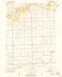
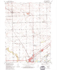
 1925 Yorkville1925 Print · USGSKendall County in the mid-twenties shows a landscape of river-valley commerce and a dense network of interurban electric rail lines. Genealogists can locate family-named schoolhouses like Tamarack School and rural hubs such as Platteville and Helmar.2 unique versions available
 - 1940 Map of Marseilles, 1958 Print
 1940 Marseilles1958 Print · USGSLaSalle and Grundy counties appear here during the transition from the canal era to the railway age. Genealogists and local historians can trace family-named school sites like Ness School and Barry School or locate the village of Stavanger.
 - 1948 Map of Sandwich, 1965 Print
 1948 Sandwich1965 Print · USGSThe Fox River valley in the late 1940s is a landscape of established rail towns and deep rural roots. Researchers can trace the Indian Boundary Line or locate family landmarks like French Ch, Oak Mound Cem, and the Sleezer Sch.
 - 1950 Map of Sandwich
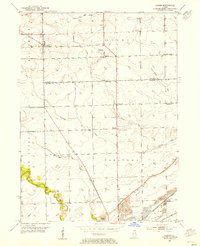
 1950 Sandwich1950 Print · USGSNorthern Illinois prairie and river valleys come alive in the mid-century, following the rail lines of the Chicago Burlington and Quincy. Trace family roots at the Sandwich Fair Grounds or local landmarks like Maramech Hill and State Boys Training School.2 unique versions available
 - 1953 Map of Plattville, 1955 Print
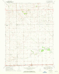
 1953 Plattville1955 Print · USGSKendall County agriculture and rural life are captured here during the early fifties, showing the region's established farm-to-market landscape. Researchers can locate specific community hubs like Helmar, the Emanuel Church, and local schoolhouses like Cross Sch.2 unique versions available
 - 1953 Map of Lisbon, 1955 Print
 1953 Lisbon1955 Print · USGSKendall and Grundy Counties were still defined by their rural character and rail-linked industry in the early fifties. Genealogists can locate several family-named landmarks and country schools including Porter Sch, Cryder Cem, and the Gore Sch.3 unique versions available
 - 1954 Map of Yorkville, 1959 Print
 1954 Yorkville1959 Print · USGSKendall County in the mid-1950s shows a balance between growing riverside towns and an expansive agricultural interior. Genealogists can trace family roots through rural landmarks like Naausay Ch, Jericho Cem, and the long-standing diagonal of the Old Indian Boundary.2 unique versions available
 - 1954 Map of Morris, 1960 Print
 1954 Morris1960 Print · USGSGrundy County in the mid-fifties is a landscape of industrial transition, where coal mining and river navigation drive local growth. Researchers can trace the extensive Strip Mine works around Coal City or locate family roots at Evergreen Cem and Sulphur Springs Sch.2 unique versions available
 - 1958 Map of Aurora, 1969 Print
 1958 Aurora1969 Print · USGSNorthern Illinois in the late fifties shows a landscape of powerful river industry and expanding transport corridors. Genealogists and historians can trace the development of Aurora and Joliet or locate sites like the Elwood Ordnance Plant and Starved Rock.3 unique versions available
 - 1961 Map of Aurora
 1961 Aurora1961 Print · USGSNorthern Illinois at the height of the post-war era reveals a landscape of massive industrial works and thriving river towns. Genealogists and historians can trace the paths of the Lincoln Highway or locate long-standing landmarks like the Green River Ordnance Plant and Starved Rock State Park.
 - 1970 Map of Stavanger, 1972 Print
 1970 Stavanger1972 Print · USGSThe rural prairie lands of Grundy and LaSalle counties are shown in detail as they appeared in the early seventies. Genealogists can locate family names at Holderman and Hoge Cem or trace the local community near Stavanger and the Nettle Creek Sch.
 - 1971 Map of Newark, 1973 Print
 1971 Newark1973 Print · USGSKendall and La Salle counties come together at the start of the 1970s, as the river-and-rail corridor supports a string of small settlements. Genealogists can trace family roots at the Millington Newark Cem or locate the old Bushnell School and the community at Lisbon Center.2 unique versions available
 - 1985 Map of Ottawa
 1985 Ottawa1985 Print · USGSThe Illinois River valley in the mid-1980s shows a landscape balancing river commerce with sprawling energy and mining operations. Researchers can trace the layout of mining towns like Coal City or find family landmarks such as Oakwood Memorial Cem and Smiths Mound.
 - 1985 Map of Aurora, 1989 Print
 1985 Aurora1989 Print · USGSNortheastern Illinois is captured in the mid-1980s as suburban growth began to bridge the gap between the Fox River cities and the outer prairies. Researchers can trace the development of Naperville and Aurora or locate rural landmarks like Fairview Cem and the Illinois and Michigan Canal.
 - 1991 Map of Ottawa
 1991 Ottawa1991 Print · USGSNorth-central Illinois in the early nineties remains a vital corridor of river commerce and heavy rail. Genealogists and historians can trace the legacy of industrial mining near Morris or explore the river-bluff geography of Starved Rock State Park and Buffalo Rock.
 - 1993 Map of Lisbon, 1994 Print
 1993 Lisbon1994 Print · USGSLisbon and Morris appear at the start of the nineties, where the quiet prairie of Kendall and Grundy counties meets the historic canal corridor. Researchers can trace family sites at Saratoga Cem and Saratoga Sch Cem or locate the Nelson Landing Strip and John Moore Park.
 - 1993 Map of Plattville, 1994 Print
 1993 Plattville1994 Print · USGSThe rural prairie of Kendall County is captured here in the early nineties, showing a landscape of established family farms and crossroads communities. Genealogists and local historians can locate Emanuel Cem, Cross Sch, and the historical Chicago Indian Reservation Boundary.
 - 2012 Map of Newark, 2012 Print
 2012 Newark2012 Print · USGSCovers Big Grove Township, including Yorkville, Newark, and other nearby areas
 - 2012 Map of Lisbon, 2012 Print
 2012 Lisbon2012 Print · USGSCovers Big Grove Township, including Channahon, Morris, and other nearby areas
 - 2012 Map of Stavanger, 2012 Print
 2012 Stavanger2012 Print · USGSCovers Big Grove Township, including Nettle Creek, Nettle Creek Township, and other nearby areas
 - 2012 Map of Plattville, 2012 Print
 2012 Plattville2012 Print · USGSCovers Big Grove Township, including Yorkville, Fox, and other nearby areas
Showing maps 1-25 of 41
Top cities near Big Grove Township
- Aurora historical maps
- Joliet historical maps
- Oswego historical maps
- Yorkville historical maps
- Channahon historical maps
- Morris historical maps
See more
Top neighborhoods of Big Grove Township
Frequently asked questions
- What are the different types of historical maps available for Big Grove Township?
- What is the oldest map of Big Grove Township?
- Where can I purchase historical maps of Big Grove Township for my home or office?
- Where can I download high-res historical maps of Big Grove Township?
- Are there historical topographic maps available for Big Grove Township?
- Is there historical aerial imagery available for Big Grove Township?
- Where are historical maps of Big Grove Township sourced from?