1970s Maps of Meriden Township, Illinois
Explore 2 historic maps of Meriden Township from the 1970s. These maps offer a rare glimpse into what life looked like during the 1970s — showing old roads, neighborhoods, homes, and landmarks that have changed or disappeared over time.
Whether you're researching your family's past, planning a metal detecting trip, or studying how Meriden Township's landscape evolved across the 1970s, these high-resolution maps are a powerful tool for exploring the history of this region.
- Focus on a specific era: All maps on this page are from the 1970s, giving you a focused view of this time period.
- See what’s changed: Compare century-old streets, trails, and buildings to today's modern landscape using overlays and satellite layers.
- Research with precision: Use these maps for genealogy, historical research, land use analysis, or educational projects.
- View, download, or print: Maps are fully viewable online in high resolution, and can be downloaded or printed for your own records.
Start exploring Meriden Township's history through authentic maps from the 1970s. This is your window into the past.
Meriden Township, IL maps
(2)- 1971 Map of Paw Paw, 1973 Print
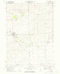 1971 Paw Paw1973 Print · USGSNorthern Illinois farm country near the intersection of Lee, DeKalb, and La Salle Counties is shown here in the early 1970s. Trace family history at the Wyoming Cemetery, locate the Rogers Brothers Landing Strip, and follow the Chicago Burlington and Northern Railroad through Rollo and Radley.
 - 1971 Map of Earlville, 1973 Print
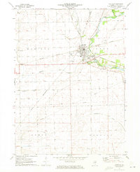 1971 Earlville1973 Print · USGSIn the early 1970s, the Illinois prairie around Earlville remained a landscape of rail junctions and rural townships. Researchers can trace family history at Tripp Cem or Carter Cem and follow the path of the Old Indian Treaty Boundary.
End of results
Showing maps 1-2 of 2
Top cities near Meriden Township
- Peru historical maps
- LaSalle historical maps
- Mendota historical maps
- Spring Valley historical maps
- Dayton historical maps
- Earlville historical maps
See more
Top neighborhoods of Meriden Township
Frequently asked questions
- What are the different types of historical maps available for Meriden Township?
- What is the oldest map of Meriden Township?
- Where can I purchase historical maps of Meriden Township for my home or office?
- Where can I download high-res historical maps of Meriden Township?
- Are there historical topographic maps available for Meriden Township?
- Is there historical aerial imagery available for Meriden Township?
- Where are historical maps of Meriden Township sourced from?