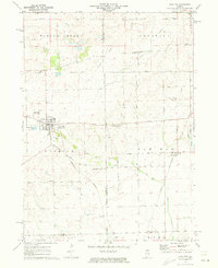
1971 Map of Paw Paw
USGS Topo · Published 1973About this map
The agricultural landscape of Lee, DeKalb, and La Salle Counties centers on the community of Paw Paw, where the Chicago Burlington and Northern Railroad intersects a grid of country roads. This 1971 field-checked survey reveals a region defined by its small rural settlements and family-named landmarks. Smaller clusters like Rollo and the station at Radley are situated along the rail line, while local infrastructure such as the Rogers Brothers Landing Strip and several Gravel Pits illustrate the local aviation and extractive needs of the early 1970s.
Find a feature on this map
36 named features on this map. Tap any name to fly to it.
Don’t see what you’re looking for? This feature index may not catch every label — zoom into the map to look around manually.
Map Details
Editions of this 1971 Paw Paw Map
This is the sole edition of this map. No revisions or reprints were ever made.
Other maps of this area

1934 · De Kalb
USGS Topo · 1:62,500

1937 · De Kalb
USGS Topo · 1:62,500

1951 · Earlville
USGS Topo · 1:62,500

1952 · Rochelle
USGS Topo · 1:62,500

1952 · Mendota
USGS Topo · 1:62,500

1958 · Aurora
USGS Topo · 1:250,000

1961 · Aurora
USGS Topo · 1:250,000
1971 · Leland
USGS Topo · 1:24,000
1971 · Lee
USGS Topo · 1:24,000
1971 · Waterman
USGS Topo · 1:24,000