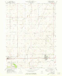
1971 Map of Waterman
USGS Topo · Published 1973About this map
Waterman and the surrounding DeKalb County prairie land are defined here by a strictly organized grid of rural roads and rail lines in the early 1970s. The landscape is anchored by the crossing of the Burlington Northern and Chicago and North Western railroads, which facilitated the region's agricultural economy. This survey documents the specific locations of pioneer-era landmarks, most notably the Chief Shabbona Grave located within the Chief Shabbona Forest Preserve.
Find a feature on this map
31 named features on this map. Tap any name to fly to it.
Don’t see what you’re looking for? This feature index may not catch every label — zoom into the map to look around manually.
Map Details
Editions of this 1971 Waterman Map
This is the sole edition of this map. No revisions or reprints were ever made.
Other maps of this area

1934 · De Kalb
USGS Topo · 1:62,500

1937 · De Kalb
USGS Topo · 1:62,500

1937 · Sycamore
USGS Topo · 1:62,500

1948 · Sandwich
USGS Topo · 1:62,500

1950 · Sandwich
USGS Topo · 1:62,500

1951 · Earlville
USGS Topo · 1:62,500

1958 · Aurora
USGS Topo · 1:250,000

1961 · Aurora
USGS Topo · 1:250,000
1968 · Sycamore
USGS Topo · 1:24,000
1968 · Hinckley
USGS Topo · 1:24,000