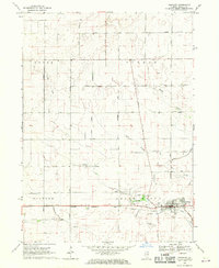
1968 Map of Hinckley
USGS Topo · Published 1970About this map
The village of Hinckley serves as the focal point of this DeKalb County landscape, where the Chicago Burlington and Quincy railroad tracks run parallel to the southern settlement boundary. The town’s social and spiritual foundations are anchored by Immanuel Ch and Pioneer Park, while the surrounding terrain is defined by the drainage of Little Rock Creek and Somonauk Creek.
Find a feature on this map
26 named features on this map. Tap any name to fly to it.
Don’t see what you’re looking for? This feature index may not catch every label — zoom into the map to look around manually.
Map Details
Editions of this 1968 Hinckley Map
This is the sole edition of this map. No revisions or reprints were ever made.
Other maps of this area

1934 · De Kalb
USGS Topo · 1:62,500

1937 · De Kalb
USGS Topo · 1:62,500

1937 · Sycamore
USGS Topo · 1:62,500

1948 · Sandwich
USGS Topo · 1:62,500

1950 · Sandwich
USGS Topo · 1:62,500

1951 · Earlville
USGS Topo · 1:62,500

1958 · Aurora
USGS Topo · 1:250,000

1961 · Aurora
USGS Topo · 1:250,000
1968 · Sycamore
USGS Topo · 1:24,000
1968 · Big Rock
USGS Topo · 1:24,000