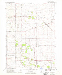
1968 Map of Big Rock
USGS Topo · Published 1970About this map
Agricultural patterns and small rural centers define this portion of the Illinois prairie in the late 1960s. The landscape is dominated by a grid of section roads like Harter Road and Pritchard Road, connecting the town of Big Rock in the south with Kaneville and the small settlement of Troxel. The Chicago Burlington and Quincy railroad line cuts through the southern tier, serving the local grain and freight economy. Waterways such as Welch Creek and the West Branch of Big Rock Creek meander across the townships, often flanked by the numerous Gravel Pits that suggest a localized extractive industry alongside farming. Genealogists will find the West Big Rock Cem and Pierce Community Ch as key landmarks of the early community footprint, while Plowmans Park provides a glimpse into the area's local recreational spaces during this period.
Find a feature on this map
42 named features on this map. Tap any name to fly to it.
Don’t see what you’re looking for? This feature index may not catch every label — zoom into the map to look around manually.
Map Details
Editions of this 1968 Big Rock Map
2 editions found
Other maps of this area

1925 · Yorkville
USGS Topo · 1:62,500

1932 · Geneva
USGS Topo · 1:62,500

1937 · Sycamore
USGS Topo · 1:62,500

1948 · Geneva
USGS Topo · 1:62,500

1948 · Sandwich
USGS Topo · 1:62,500

1950 · Sandwich
USGS Topo · 1:62,500

1953 · Yorkville
USGS Topo · 1:24,000
1954 · Yorkville
USGS Topo · 1:62,500

1958 · Aurora
USGS Topo · 1:250,000

1961 · Aurora
USGS Topo · 1:250,000