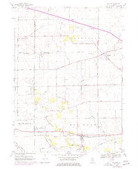
1968 Map of Big Rock
USGS Topo · Published 1977About this map
Agricultural patterns and small rural centers define the landscape of southwestern Kane County during the late 1960s. The village of Big Rock sits at the junction of the Chicago Burlington and Quincy railroad and Big Rock Creek, serving as a primary focal point alongside Kaneville to the northeast. This period shows the transition of traditional farm country as the East West Tollway begins to cut through the northern townships of Pierce and Kaneville, signaling a shift toward modern regional connectivity.
Find a feature on this map
45 named features on this map. Tap any name to fly to it.
Don’t see what you’re looking for? This feature index may not catch every label — zoom into the map to look around manually.
Map Details
Editions of this 1968 Big Rock Map
2 editions found
Other maps of this area

1925 · Yorkville
USGS Topo · 1:62,500

1932 · Geneva
USGS Topo · 1:62,500

1937 · Sycamore
USGS Topo · 1:62,500

1948 · Geneva
USGS Topo · 1:62,500

1948 · Sandwich
USGS Topo · 1:62,500

1950 · Sandwich
USGS Topo · 1:62,500

1953 · Yorkville
USGS Topo · 1:24,000
1954 · Yorkville
USGS Topo · 1:62,500

1958 · Aurora
USGS Topo · 1:250,000

1961 · Aurora
USGS Topo · 1:250,000