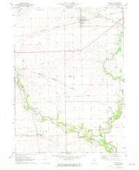
1971 Map of Leland
USGS Topo · Published 1972About this map
The village of Leland serves as the primary hub of this northern Illinois landscape, positioned where the Burlington Northern railroad cuts through the agricultural heartland of LaSalle County. This 1971 survey captures the region as a grid of rural life, anchored by small settlements like Baker and Harding. A significant historical landmark, the Old Indian Treaty Boundary, bisects the southern half of the quadrangle, reflecting the early surveying history that defined property lines in this part of the state.
Find a feature on this map
26 named features on this map. Tap any name to fly to it.
Don’t see what you’re looking for? This feature index may not catch every label — zoom into the map to look around manually.
Map Details
Editions of this 1971 Leland Map
2 editions found
Other maps of this area

1892 · Marseilles
USGS Topo · 1:62,500

1892 · Ottawa
USGS Topo · 1:62,500

1915 · Ottawa
USGS Topo · 1:62,500

1916 · Marseilles
USGS Topo · 1:62,500

1940 · Marseilles
USGS Topo · 1:62,500

1946 · Ottawa
USGS Topo · 1:62,500

1948 · Sandwich
USGS Topo · 1:62,500

1950 · Sandwich
USGS Topo · 1:62,500

1951 · Earlville
USGS Topo · 1:62,500

1958 · Aurora
USGS Topo · 1:250,000