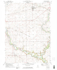
1971 Map of Leland
USGS Topo · Published 1973About this map
Leland and the surrounding townships of Adams, Earl, and Freedom define this LaSalle County agricultural landscape during the early 1970s. The map captures a moment of transition for the region's transport network, featuring the Burlington Northern line and a distinct Old Railroad Grade that speaks to former rail paths through the prairie. One of the most significant historical markers is the Old Indian Treaty Boundary, which diagonally bisects the section lines and indicates the lasting cartographic impact of early nineteenth-century land cessions.
Find a feature on this map
26 named features on this map. Tap any name to fly to it.
Don’t see what you’re looking for? This feature index may not catch every label — zoom into the map to look around manually.
Map Details
Editions of this 1971 Leland Map
2 editions found
Other maps of this area

1892 · Marseilles
USGS Topo · 1:62,500

1892 · Ottawa
USGS Topo · 1:62,500

1915 · Ottawa
USGS Topo · 1:62,500

1916 · Marseilles
USGS Topo · 1:62,500

1940 · Marseilles
USGS Topo · 1:62,500

1946 · Ottawa
USGS Topo · 1:62,500

1948 · Sandwich
USGS Topo · 1:62,500

1950 · Sandwich
USGS Topo · 1:62,500

1951 · Earlville
USGS Topo · 1:62,500

1958 · Aurora
USGS Topo · 1:250,000