1970s Maps of Viola Township, Illinois
Explore 2 historic maps of Viola Township from the 1970s. These maps offer a rare glimpse into what life looked like during the 1970s — showing old roads, neighborhoods, homes, and landmarks that have changed or disappeared over time.
Whether you're researching your family's past, planning a metal detecting trip, or studying how Viola Township's landscape evolved across the 1970s, these high-resolution maps are a powerful tool for exploring the history of this region.
- Focus on a specific era: All maps on this page are from the 1970s, giving you a focused view of this time period.
- See what’s changed: Compare century-old streets, trails, and buildings to today's modern landscape using overlays and satellite layers.
- Research with precision: Use these maps for genealogy, historical research, land use analysis, or educational projects.
- View, download, or print: Maps are fully viewable online in high resolution, and can be downloaded or printed for your own records.
Start exploring Viola Township's history through authentic maps from the 1970s. This is your window into the past.
Viola Township, IL maps
(2)- 1975 Map of Steward, 1978 Print
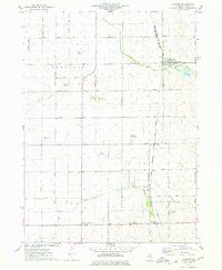 1975 Steward1978 Print · USGSSteward and the surrounding Illinois prairie are shown in the mid-1970s at the height of its rail-and-air utility. Researchers can trace family-named roads and rural infrastructure like Twelvemile Corner, Scarboro, and the Bresson Airport.
 - 1975 Map of Ashton, 1978 Print
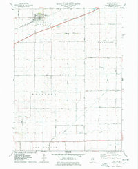 1975 Ashton1978 Print · USGSIn the mid-1970s, the village of Ashton and its surrounding townships anchored a productive Lee County landscape. Researchers can trace family roots and old land boundaries near the Reynolds Church, Reynolds Cemetery, and the Sword Landing Strip.
End of results
Showing maps 1-2 of 2
Top cities near Viola Township
- Rochelle historical maps
- Mendota historical maps
- Amboy historical maps
- Earlville historical maps
- Hillcrest historical maps
- Ashton historical maps
See more
Top neighborhoods of Viola Township
Frequently asked questions
- What are the different types of historical maps available for Viola Township?
- What is the oldest map of Viola Township?
- Where can I purchase historical maps of Viola Township for my home or office?
- Where can I download high-res historical maps of Viola Township?
- Are there historical topographic maps available for Viola Township?
- Is there historical aerial imagery available for Viola Township?
- Where are historical maps of Viola Township sourced from?