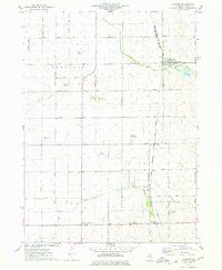
1975 Map of Steward
USGS Topo · Published 1978About this map
The village of Steward serves as the focal point of this Lee County landscape, where the Chicago Milwaukee St Paul and Pacific railroad intersects with the B N line. This junction highlights a regional economy defined by agriculture and transit during the mid-1970s. The surrounding prairie is notably marked by an unusual density of private aviation infrastructure, including the Staton Landing Strip, Ranken Landing Strip, and Bresson Airport, suggesting a period of high utility for light aircraft among the area's farming community. Waterways like Steward Creek and Willow Creek meander through the townships of Reynolds and Willow Creek, while local landmarks such as Twelvemile Corner and the Twin Grove Cem provide specific points of interest for genealogists and local historians studying the rural settlement patterns of northern Illinois.
Find a feature on this map
42 named features on this map. Tap any name to fly to it.
Don’t see what you’re looking for? This feature index may not catch every label — zoom into the map to look around manually.
Map Details
Editions of this 1975 Steward Map
This is the sole edition of this map. No revisions or reprints were ever made.
Other maps of this area

1934 · De Kalb
USGS Topo · 1:62,500

1937 · De Kalb
USGS Topo · 1:62,500

1951 · Earlville
USGS Topo · 1:62,500

1952 · Rochelle
USGS Topo · 1:62,500

1952 · Mendota
USGS Topo · 1:62,500

1958 · Aurora
USGS Topo · 1:250,000

1961 · Aurora
USGS Topo · 1:250,000
1971 · Lee
USGS Topo · 1:24,000
1971 · Paw Paw
USGS Topo · 1:24,000
1971 · Creston
USGS Topo · 1:24,000