1990s Maps of Viola Township, Illinois
Explore 2 historic maps of Viola Township from the 1990s. These maps offer a rare glimpse into what life looked like during the 1990s — showing old roads, neighborhoods, homes, and landmarks that have changed or disappeared over time.
Whether you're researching your family's past, planning a metal detecting trip, or studying how Viola Township's landscape evolved across the 1990s, these high-resolution maps are a powerful tool for exploring the history of this region.
- Focus on a specific era: All maps on this page are from the 1990s, giving you a focused view of this time period.
- See what’s changed: Compare century-old streets, trails, and buildings to today's modern landscape using overlays and satellite layers.
- Research with precision: Use these maps for genealogy, historical research, land use analysis, or educational projects.
- View, download, or print: Maps are fully viewable online in high resolution, and can be downloaded or printed for your own records.
Start exploring Viola Township's history through authentic maps from the 1990s. This is your window into the past.
Viola Township, IL maps
(2)- 1993 Map of Compton
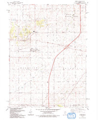 1993 Compton1993 Print · USGSThe Illinois prairie around Compton is shown here in the early nineties as a landscape defined by its agricultural roots and old rail lines. Researchers can trace the Old Railroad Grade through Compton and locate historic sites like Fisk Cem and the settlement of The Burg.
 - 1993 Map of Steward
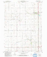 1993 Steward1993 Print · USGSSteward and the surrounding Lee County townships are captured in the early 1990s as a landscape of productive fields and private airfields. Researchers can locate family landmarks like Twin Grove Cem, Twelvemile Corner, and the Ranken Landing Strip.
End of results
Showing maps 1-2 of 2
Top cities near Viola Township
- Rochelle historical maps
- Mendota historical maps
- Amboy historical maps
- Earlville historical maps
- Hillcrest historical maps
- Ashton historical maps
See more
Top neighborhoods of Viola Township
Frequently asked questions
- What are the different types of historical maps available for Viola Township?
- What is the oldest map of Viola Township?
- Where can I purchase historical maps of Viola Township for my home or office?
- Where can I download high-res historical maps of Viola Township?
- Are there historical topographic maps available for Viola Township?
- Is there historical aerial imagery available for Viola Township?
- Where are historical maps of Viola Township sourced from?