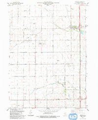
1993 Map of Steward
USGS Topo · Published 1993About this map
Steward and the surrounding agricultural townships of Lee County are mapped here in the early 1990s, revealing a landscape defined by highly localized infrastructure. The presence of multiple small-scale airfields, such as Staton Landing Strip, Ranken Landing Strip, and Thompson Landing Strip, suggests a unique reliance on private aviation within this farming community. These strips, alongside Bresson Airport, are interspersed among established rural centers like Steward and Scarboro.
Find a feature on this map
43 named features on this map. Tap any name to fly to it.
Don’t see what you’re looking for? This feature index may not catch every label — zoom into the map to look around manually.
Map Details
Editions of this 1993 Steward Map
This is the sole edition of this map. No revisions or reprints were ever made.
Other maps of this area

1934 · De Kalb
USGS Topo · 1:62,500

1937 · De Kalb
USGS Topo · 1:62,500

1951 · Earlville
USGS Topo · 1:62,500

1952 · Rochelle
USGS Topo · 1:62,500

1952 · Mendota
USGS Topo · 1:62,500

1958 · Aurora
USGS Topo · 1:250,000

1961 · Aurora
USGS Topo · 1:250,000
1971 · Lee
USGS Topo · 1:24,000
1971 · Paw Paw
USGS Topo · 1:24,000
1971 · Creston
USGS Topo · 1:24,000