1930s Maps of Macon County, Illinois
Explore 2 historic maps of Macon County from the 1930s. These maps offer a rare glimpse into what life looked like during the 1930s — showing old roads, neighborhoods, homes, and landmarks that have changed or disappeared over time.
Whether you're researching your family's past, planning a metal detecting trip, or studying how Macon County's landscape evolved across the 1930s, these high-resolution maps are a powerful tool for exploring the history of this region.
- Focus on a specific era: All maps on this page are from the 1930s, giving you a focused view of this time period.
- See what’s changed: Compare century-old streets, trails, and buildings to today's modern landscape using overlays and satellite layers.
- Research with precision: Use these maps for genealogy, historical research, land use analysis, or educational projects.
- View, download, or print: Maps are fully viewable online in high resolution, and can be downloaded or printed for your own records.
Start exploring Macon County's history through authentic maps from the 1930s. This is your window into the past.
Macon County, IL maps
(2)- 1933 Map of Decatur
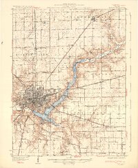 1933 Decatur1933 Print · USGSThe rail-and-river hub of Decatur is captured here in the early thirties, showing a landscape defined by industrial growth and rural school districts. Genealogists can trace family landmarks like Antioch Ch or dozens of local schoolhouses including Blue Door Sch and Mound Sch.3 unique versions available
 - 1937 Map of Monticello
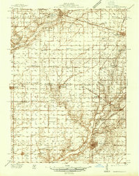 1937 Monticello1937 Print · USGSIn the mid-1930s, this portion of Piatt and DeWitt counties was a bustling corridor of rail lines and rural school districts. Genealogists can locate family landmarks like Campground Cem or trace the vanished district schools like Watson Sch and Harmony Sch.2 unique versions available
End of results
Showing maps 1-2 of 2
Top cities of Macon County
- Decatur historical maps
- Mount Zion historical maps
- Forsyth historical maps
- Maroa historical maps
- Long Creek historical maps
- Harristown historical maps
See more
Frequently asked questions
- What are the different types of historical maps available for Macon County?
- What is the oldest map of Macon County?
- Where can I purchase historical maps of Macon County for my home or office?
- Where can I download high-res historical maps of Macon County?
- Are there historical topographic maps available for Macon County?
- Is there historical aerial imagery available for Macon County?
- Where are historical maps of Macon County sourced from?