1970s Maps of Macon County, Illinois
Explore 3 historic maps of Macon County from the 1970s. These maps offer a rare glimpse into what life looked like during the 1970s — showing old roads, neighborhoods, homes, and landmarks that have changed or disappeared over time.
Whether you're researching your family's past, planning a metal detecting trip, or studying how Macon County's landscape evolved across the 1970s, these high-resolution maps are a powerful tool for exploring the history of this region.
- Focus on a specific era: All maps on this page are from the 1970s, giving you a focused view of this time period.
- See what’s changed: Compare century-old streets, trails, and buildings to today's modern landscape using overlays and satellite layers.
- Research with precision: Use these maps for genealogy, historical research, land use analysis, or educational projects.
- View, download, or print: Maps are fully viewable online in high resolution, and can be downloaded or printed for your own records.
Start exploring Macon County's history through authentic maps from the 1970s. This is your window into the past.
Macon County, IL maps
(3)- 1979 Map of Maroa, 1980 Print
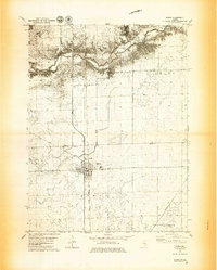 1979 Maroa1980 Print · USGSMaroa and the surrounding prairie are captured in the late seventies at a peak of rail-and-road connectivity on the De Witt and Macon County line. Researchers can locate the Maroa Cem, the Texas Ch, and small rail siding of Ospur amidst the fertile farmland.2 unique versions available
 - 1979 Map of Weldon West, 1980 Print
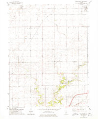 1979 Weldon West1980 Print · USGSDe Witt County and the Macon County line are captured in the late seventies, a period of established prairie farming and rail transport. Genealogists can locate Shiloh Chapel, the Chandler Cem, and the rural community of Lane along the Illinois Central Gulf tracks.
 - 1979 Map of Weldon East, 1980 Print
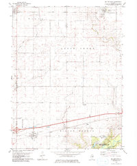 1979 Weldon East1980 Print · USGSPiatt County farmland in the late seventies is marked by the busy Illinois Central Gulf rail line and quiet rural townships. Genealogists can locate family sites near Weldon, DeLand, or the wooded grounds of Robert Allerton Park.
End of results
Showing maps 1-3 of 3
Top cities of Macon County
- Decatur historical maps
- Mount Zion historical maps
- Forsyth historical maps
- Maroa historical maps
- Long Creek historical maps
- Harristown historical maps
See more
Frequently asked questions
- What are the different types of historical maps available for Macon County?
- What is the oldest map of Macon County?
- Where can I purchase historical maps of Macon County for my home or office?
- Where can I download high-res historical maps of Macon County?
- Are there historical topographic maps available for Macon County?
- Is there historical aerial imagery available for Macon County?
- Where are historical maps of Macon County sourced from?